Endangered
An application has been made to demolish or significantly alter these buildings.
If a property is deemed to have historic merit, the Town has the option of placing a stay of demolition for up to 12 months — or 18 months for National Register properties — to allow the Town and the owner to discuss alternatives to demolition of the property.
Demolition hearing:
2024-04-09partial demolition carriage house only, house not endangered
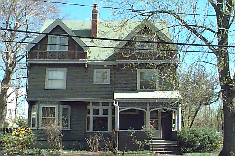
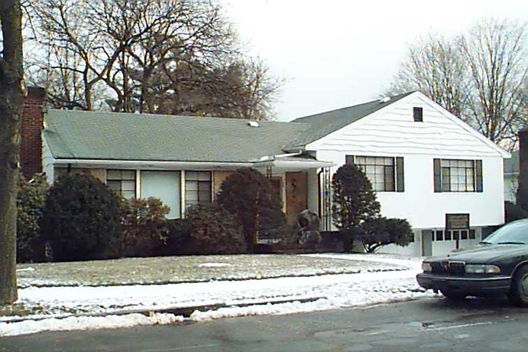
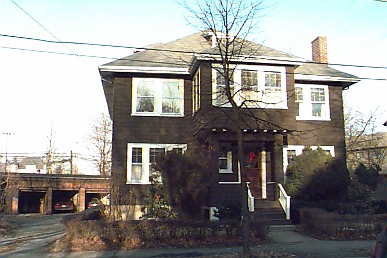
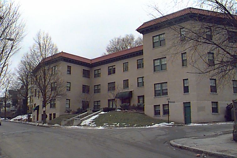
212 Aspinwall Ave
Built:
c1887Class:
Single Family HouseLand area:
12,213 sfFAR:
0.31Owner:
Robert L Jr Allen TrFY24:
$1,919,100 Δ-8.70%| FY | Assessed | Change |
| 24 | $1,919,100 | -8.70% |
| 23 | $2,101,900 | 5.00% |
| 22 | $2,001,800 | 4.00% |
| 21 | $1,924,800 | 5.97% |
| 20 | $1,816,400 | 5.00% |
| 19 | $1,729,900 | 10.38% |
| 18 | $1,567,200 | 6.00% |
| 17 | $1,478,500 | 7.00% |
| 16 | $1,381,800 | 11.92% |
| 15 | $1,234,600 | 7.93% |
| 14 | $1,143,900 | 3.00% |
| 13 | $1,110,600 | 0.00% |
| 12 | $1,110,600 | 0.81% |
| 11 | $1,101,700 | 0.00% |
| 10 | $1,101,700 | 0.00% |
| 09 | $1,101,700 | 0.62% |
| 08 | $1,094,900 | -4.25% |
| 07 | $1,143,500 | 0.02% |
| 06 | $1,143,300 | 12.81% |
| 05 | $1,013,500 | 9.51% |
| 04 | $925,500 | 10.01% |
| 03 | $841,300 | 13.89% |
| 02 | $738,700 |
Historic name:
Richards, John J. HouseNeighborhood:
Lawrence SchoolStyle(s):
Queen AnneUse(s):
Single Family Dwelling HouseSignificance(s):
Architecture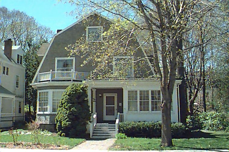
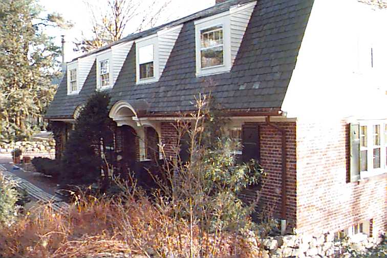
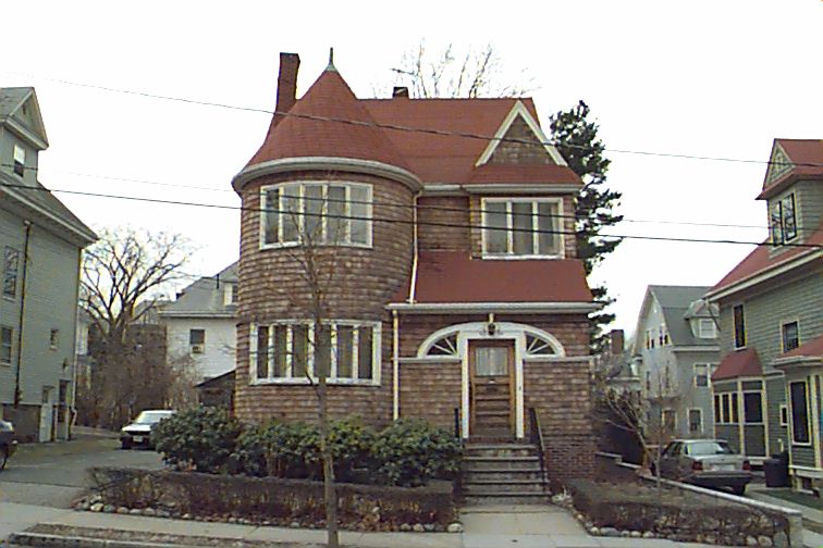
66 Toxteth St
Built:
1892Class:
Single Family HouseLand area:
10,500 sfFAR:
0.31Owner:
Samuel & Anne Freeh EngelFY24:
$2,142,200 Δ9.93%| FY | Assessed | Change |
| 24 | $2,142,200 | 9.93% |
| 23 | $1,948,700 | 4.99% |
| 22 | $1,856,000 | 4.00% |
| 21 | $1,784,600 | 6.26% |
| 20 | $1,679,400 | 5.00% |
| 19 | $1,599,400 | 11.16% |
| 18 | $1,438,800 | 6.00% |
| 17 | $1,357,400 | 7.00% |
| 16 | $1,268,600 | 12.29% |
| 15 | $1,129,800 | 7.74% |
| 14 | $1,048,600 | 3.00% |
| 13 | $1,018,100 | 0.00% |
| 12 | $1,018,100 | 0.76% |
| 11 | $1,010,400 | -1.81% |
| 10 | $1,029,000 | 0.00% |
| 09 | $1,029,000 | 0.44% |
| 08 | $1,024,500 | -4.18% |
| 07 | $1,069,200 | 0.00% |
| 06 | $1,069,200 | 12.20% |
| 05 | $952,900 | 7.01% |
| 04 | $890,500 | 10.10% |
| 03 | $808,800 | 13.39% |
| 02 | $713,300 |
Historic name:
Thomas, Edward I. HouseNeighborhood:
Lawrence SchoolStyle(s):
Shingle StyleUse(s):
Single Family Dwelling HouseSignificance(s):
Architecture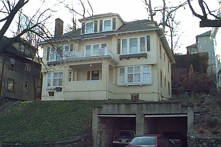
111 University Rd
Built:
1916Class:
Two-Family HouseLand area:
5,866 sfFAR:
0.62Owner:
111 University Rd LLCFY24:
$2,481,700 Δ7.80%| FY | Assessed | Change |
| 24 | $2,481,700 | 7.80% |
| 23 | $2,302,200 | 5.00% |
| 22 | $2,192,600 | 4.00% |
| 21 | $2,108,200 | 1.86% |
| 20 | $2,069,700 | 5.00% |
| 19 | $1,971,100 | 12.04% |
| 18 | $1,759,300 | 8.00% |
| 17 | $1,629,000 | 10.00% |
| 16 | $1,480,900 | 13.95% |
| 15 | $1,299,600 | 9.20% |
| 14 | $1,190,100 | 5.00% |
| 13 | $1,133,400 | 0.00% |
| 12 | $1,133,400 | 2.97% |
| 11 | $1,100,700 | 0.00% |
| 10 | $1,100,700 | -10.79% |
| 09 | $1,233,800 | 10.10% |
| 08 | $1,120,600 | -2.00% |
| 07 | $1,143,500 | 0.00% |
| 06 | $1,143,500 | 6.59% |
| 05 | $1,072,800 | 6.99% |
| 04 | $1,002,700 | 10.01% |
| 03 | $911,500 | 32.10% |
| 02 | $690,000 |
Historic name:
Hopkins Trust HouseNeighborhood:
Aspinwall HillArchitect(s):
Ramsay, Harry MortonStyle(s):
CraftsmanUse(s):
Multiple Family Dwelling HouseSignificance(s):
Architecture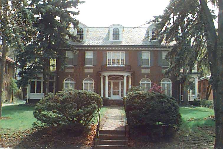
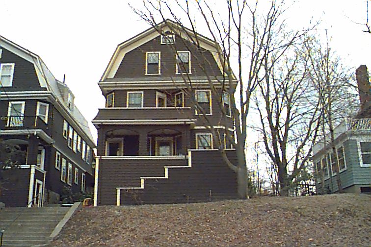
134 Clinton Rd
Built:
1926Class:
Single Family HouseLand area:
16,647 sfFAR:
0.23Owner:
Michelle A Hallee Tr; Gordon G Wong TrFY24:
$3,561,100 Δ18.36%| FY | Assessed | Change |
| 24 | $3,561,100 | 18.36% |
| 23 | $3,008,800 | 5.00% |
| 22 | $2,865,500 | 4.00% |
| 21 | $2,755,300 | 4.58% |
| 20 | $2,634,600 | 5.00% |
| 19 | $2,509,100 | 1.95% |
| 18 | $2,461,200 | 6.07% |
| 17 | $2,320,300 | 7.00% |
| 16 | $2,168,500 | 7.00% |
| 15 | $2,026,600 | 3.04% |
| 14 | $1,966,900 | 3.00% |
| 13 | $1,909,600 | 0.00% |
| 12 | $1,909,600 | 4.62% |
| 11 | $1,825,300 | 0.00% |
| 10 | $1,825,300 | 0.10% |
| 09 | $1,823,400 | 3.13% |
| 08 | $1,768,000 | -4.00% |
| 07 | $1,841,700 | 0.00% |
| 06 | $1,841,700 | 10.54% |
| 05 | $1,666,100 | 7.00% |
| 04 | $1,557,100 | 22.72% |
| 03 | $1,268,800 | 23.70% |
| 02 | $1,025,700 |
Historic name:
Chamberlain - Gordon HouseNeighborhood:
Fisher HillArchitect(s):
Deane, Norman H.Style(s):
Colonial RevivalUse(s):
Single Family Dwelling HouseSignificance(s):
Architecture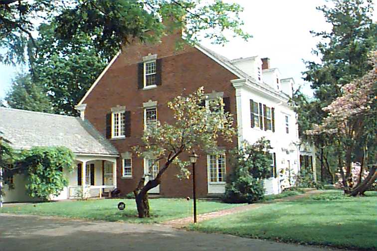
41 Codman Rd
Built:
1919Class:
Single Family HouseLand area:
43,605 sfFAR:
0.14Owner:
41 Codman Road LLCFY24:
$3,565,200 Δ16.77%| FY | Assessed | Change |
| 24 | $3,565,200 | 16.77% |
| 23 | $3,053,300 | 5.00% |
| 22 | $2,907,900 | 4.00% |
| 21 | $2,796,100 | 8.34% |
| 20 | $2,580,800 | 5.00% |
| 19 | $2,457,900 | 7.68% |
| 18 | $2,282,600 | 6.00% |
| 17 | $2,153,400 | 7.00% |
| 16 | $2,012,600 | 7.00% |
| 15 | $1,880,900 | 5.08% |
| 14 | $1,790,000 | 3.00% |
| 13 | $1,737,900 | 0.12% |
| 12 | $1,735,900 | 6.62% |
| 11 | $1,628,100 | 0.00% |
| 10 | $1,628,100 | -0.07% |
| 09 | $1,629,300 | -15.00% |
| 08 | $1,916,900 | -4.00% |
| 07 | $1,996,800 | 0.01% |
| 06 | $1,996,700 | -0.43% |
| 05 | $2,005,400 | 6.99% |
| 04 | $1,874,300 | 10.01% |
| 03 | $1,703,800 | 26.38% |
| 02 | $1,348,200 |
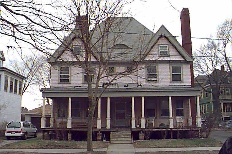
244 Heath St
Built:
1917Class:
Single Family HouseLand area:
35,119 sfFAR:
0.08Owner:
Shari Levitan TrFY24:
$3,924,700 Δ14.35%| FY | Assessed | Change |
| 24 | $3,924,700 | 14.35% |
| 23 | $3,432,200 | 5.00% |
| 22 | $3,268,700 | 4.00% |
| 21 | $3,143,000 | 6.78% |
| 20 | $2,943,500 | 6.21% |
| 19 | $2,771,500 | 8.18% |
| 18 | $2,561,900 | 6.00% |
| 17 | $2,416,900 | 7.00% |
| 16 | $2,258,800 | 7.00% |
| 15 | $2,111,000 | 6.05% |
| 14 | $1,990,600 | 3.00% |
| 13 | $1,932,600 | 0.00% |
| 12 | $1,932,600 | 3.97% |
| 11 | $1,858,800 | 0.00% |
| 10 | $1,858,800 | 0.08% |
| 09 | $1,857,300 |
12 Naples Rd
Built:
1895Class:
Single Family HouseLand area:
5,906 sfFAR:
0.58Owner:
635 Chestnut Hill Ave Real Estate Development LLCFY24:
$1,996,100 Δ-0.53%| FY | Assessed | Change |
| 24 | $1,996,100 | -0.53% |
| 23 | $2,006,700 | 5.00% |
| 22 | $1,911,200 | 4.01% |
| 21 | $1,837,600 | 6.11% |
| 20 | $1,731,800 | 5.00% |
| 19 | $1,649,300 | 10.91% |
| 18 | $1,487,100 | 5.99% |
| 17 | $1,403,000 | 7.00% |
| 16 | $1,311,200 | 7.00% |
| 15 | $1,225,400 | 12.55% |
| 14 | $1,088,800 | 3.00% |
| 13 | $1,057,100 | -2.26% |
| 12 | $1,081,500 | 9.14% |
| 11 | $990,900 | 0.00% |
| 10 | $990,900 | 0.00% |
| 09 | $990,900 | 0.70% |
| 08 | $984,000 | -4.40% |
| 07 | $1,029,300 | 0.00% |
| 06 | $1,029,300 | 22.89% |
| 05 | $837,600 | 6.99% |
| 04 | $782,900 | 10.02% |
| 03 | $711,600 | 8.71% |
| 02 | $654,600 |
Historic name:
Woodbury, Horace S. - McKay, David H. HouseNeighborhood:
North BrooklineArchitect(s):
Brown, Samuel J.Style(s):
Queen AnneUse(s):
Multiple Family Dwelling House; Single Family Dwelling HouseSignificance(s):
Architecture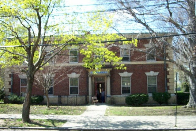
18 Williston Rd
Built:
1901Class:
Religious PropertyLand area:
8,783 sfOwner:
Sephardic Congregation Of N E; C/O David SheenahFY24:
$2,464,700 Δ8.96%| FY | Assessed | Change |
| 24 | $2,464,700 | 8.96% |
| 23 | $2,262,100 | 4.93% |
| 22 | $2,155,900 | 0.61% |
| 21 | $2,142,900 | 3.77% |
| 20 | $2,065,000 | 3.16% |
| 19 | $2,001,800 | 38.55% |
| 18 | $1,444,800 | 16.53% |
| 17 | $1,239,900 | -4.41% |
| 16 | $1,297,100 | -1.05% |
| 15 | $1,310,800 | 4.28% |
| 14 | $1,257,000 | 1.15% |
| 13 | $1,242,700 | 0.00% |
| 12 | $1,242,700 | 16.78% |
| 11 | $1,064,100 | 4.37% |
| 10 | $1,019,500 | -10.91% |
| 09 | $1,144,300 | 16.16% |
| 08 | $985,100 | 0.00% |
| 07 | $985,100 | 0.00% |
| 06 | $985,100 | 4.08% |
| 05 | $946,500 | 17.69% |
| 04 | $804,200 | 0.00% |
| 03 | $804,200 | 41.76% |
| 02 | $567,300 |
Historic name:
Watson, C. H. StableCommon name:
Saint Andrew's Mission for the DeafNeighborhood:
AberdeenArchitect(s):
Bacon and HillStyle(s):
Colonial RevivalUse(s):
Dormitory; Other Religious; Out Building; Parking GarageSignificance(s):
Architecture; Education; Religion; Transportation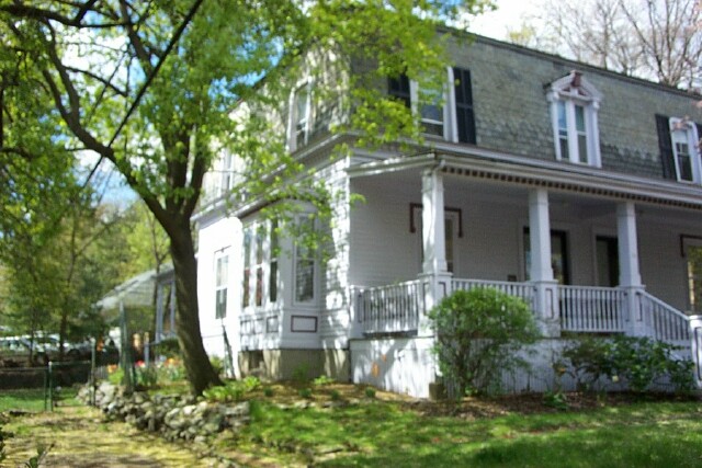
70 Francis St
Built:
1862Class:
Single Family HouseLand area:
5,100 sfFAR:
0.35Owner:
Marsha Salter Jones TrFY24:
$1,521,100 Δ10.26%| FY | Assessed | Change |
| 24 | $1,521,100 | 10.26% |
| 23 | $1,379,500 | 4.99% |
| 22 | $1,313,900 | 4.01% |
| 21 | $1,263,300 | 7.21% |
| 20 | $1,178,300 | 5.00% |
| 19 | $1,122,200 | 16.19% |
| 18 | $965,800 | 6.02% |
| 17 | $911,000 | 7.00% |
| 16 | $851,400 | 15.96% |
| 15 | $734,200 | 7.65% |
| 14 | $682,000 | 3.01% |
| 13 | $662,100 | -1.87% |
| 12 | $674,700 | 5.03% |
| 11 | $642,400 | 0.00% |
| 10 | $642,400 | 0.00% |
| 09 | $642,400 | 8.28% |
| 08 | $593,300 | -4.58% |
| 07 | $621,800 | 0.00% |
| 06 | $621,800 | 8.01% |
| 05 | $575,700 | 6.99% |
| 04 | $538,100 | 10.02% |
| 03 | $489,100 | 10.73% |
| 02 | $441,700 |
71 Green St
Built:
1910Class:
Two-Family HouseLand area:
8,658 sfFAR:
0.64Owner:
Barrett S Jones; C/O Heidi KelfFY24:
$3,184,000 Δ2.22%| FY | Assessed | Change |
| 24 | $3,184,000 | 2.22% |
| 23 | $3,114,900 | 5.00% |
| 22 | $2,966,600 | 4.00% |
| 21 | $2,852,500 | 1.35% |
| 20 | $2,814,400 | 5.00% |
| 19 | $2,680,400 | 11.79% |
| 18 | $2,397,800 | 8.00% |
| 17 | $2,220,100 | 10.00% |
| 16 | $2,018,300 | 10.00% |
| 15 | $1,834,800 | 14.50% |
| 14 | $1,602,400 | 5.00% |
| 13 | $1,526,100 | 0.00% |
| 12 | $1,526,100 | 0.14% |
| 11 | $1,523,900 | 0.00% |
| 10 | $1,523,900 | 0.00% |
| 09 | $1,523,900 | 4.52% |
| 08 | $1,458,000 | -1.51% |
| 07 | $1,480,400 | -0.50% |
| 06 | $1,487,800 | 13.65% |
| 05 | $1,309,100 | 7.01% |
| 04 | $1,223,400 | 9.99% |
| 03 | $1,112,300 | 27.84% |
| 02 | $870,100 |
30 Stetson St
Built:
1910Class:
Single Family HouseLand area:
5,000 sfFAR:
0.47Owner:
Stanley & Helen QuintFY24:
$1,734,200 Δ4.20%| FY | Assessed | Change |
| 24 | $1,734,200 | 4.20% |
| 23 | $1,664,300 | 5.00% |
| 22 | $1,585,000 | 4.00% |
| 21 | $1,524,100 | 6.94% |
| 20 | $1,425,200 | 5.00% |
| 19 | $1,357,300 | 12.72% |
| 18 | $1,204,100 | 5.99% |
| 17 | $1,136,100 | 7.13% |
| 16 | $1,060,500 | 7.00% |
| 15 | $991,100 | 13.31% |
| 14 | $874,700 | 3.00% |
| 13 | $849,200 | 0.00% |
| 12 | $849,200 | 0.64% |
| 11 | $843,800 | 0.00% |
| 10 | $843,800 | 0.00% |
| 09 | $843,800 | 2.19% |
| 08 | $825,700 | -4.20% |
| 07 | $861,900 | 0.00% |
| 06 | $861,900 | 21.33% |
| 05 | $710,400 | 6.99% |
| 04 | $664,000 | 10.01% |
| 03 | $603,600 | 8.04% |
| 02 | $558,700 |
Historic name:
Mead, Grace B. S. HouseNeighborhood:
North BrooklineArchitect(s):
Mead, Samuel W.Style(s):
Colonial RevivalUse(s):
Single Family Dwelling HouseSignificance(s):
Architecture
47 University Rd
Built:
1898Class:
Three-Family HouseLand area:
7,115 sfFAR:
0.45Owner:
47 University Realty LLC; C/O Ss Investments IncFY24:
$2,121,300 Δ10.94%| FY | Assessed | Change |
| 24 | $2,121,300 | 10.94% |
| 23 | $1,912,100 | 5.01% |
| 22 | $1,820,900 | 4.00% |
| 21 | $1,750,900 | 3.99% |
| 20 | $1,683,700 | 5.00% |
| 19 | $1,603,500 | 9.19% |
| 18 | $1,468,600 | 8.00% |
| 17 | $1,359,800 | 10.19% |
| 16 | $1,234,000 | 15.06% |
| 15 | $1,072,500 | 5.62% |
| 14 | $1,015,400 | 5.01% |
| 13 | $967,000 | 0.00% |
| 12 | $967,000 | 2.36% |
| 11 | $944,700 | 0.00% |
| 10 | $944,700 | -0.01% |
| 09 | $944,800 | 3.87% |
| 08 | $909,600 | -2.40% |
| 07 | $932,000 | 0.36% |
| 06 | $928,700 | 11.93% |
| 05 | $829,700 | 7.00% |
| 04 | $775,400 | 9.99% |
| 03 | $705,000 | 28.96% |
| 02 | $546,700 |
100 Woodcliff Rd
Built:
1954Class:
Single Family HouseLand area:
9,042 sfFAR:
0.17Owner:
Orthodox Synagogue Congregation Lubavitch; C/O James J Cotter III, EsqFY24:
$1,103,100 Δ13.75%| FY | Assessed | Change |
| 24 | $1,103,100 | 13.75% |
| 23 | $969,800 | 5.01% |
| 22 | $923,500 | 4.00% |
| 21 | $888,000 | 12.04% |
| 20 | $792,600 | 2.62% |
| 19 | $772,400 | 1.43% |
| 18 | $761,500 | 3.86% |
| 17 | $733,200 | 0.00% |
| 16 | $733,200 | 1.78% |
| 15 | $720,400 | 4.83% |
| 14 | $687,200 | 1.45% |
| 13 | $677,400 | 0.00% |
| 12 | $677,400 | 12.45% |
| 11 | $602,400 | 9.09% |
| 10 | $552,200 | 0.00% |
| 09 | $552,200 | 4.90% |
| 08 | $526,400 | -4.27% |
| 07 | $549,900 | -0.11% |
| 06 | $550,500 | 6.46% |
| 05 | $517,100 | 6.99% |
| 04 | $483,300 | 10.02% |
| 03 | $439,300 | -0.61% |
| 02 | $442,000 |
Historic name:
Silverman, Maurice HouseNeighborhood:
South Brookline; PutterhamArchitect(s):
Williams, Ralph I.Style(s):
Postwar Traditional; RanchUse(s):
Single Family Dwelling HouseSignificance(s):
Architecture
12 Williams St
Built:
1888Units:
2Class:
Single Family HouseLand area:
5,500 sfFAR:
0.53Owner:
Fred Starikov TrFY24:
$1,611,400 Δ7.07%| FY | Assessed | Change |
| 24 | $1,611,400 | 7.07% |
| 23 | $1,505,000 | 5.24% |
| 22 | $1,430,000 | 4.01% |
| 21 | $1,374,900 | 7.67% |
| 20 | $1,276,900 | 5.00% |
| 19 | $1,216,100 | 12.73% |
| 18 | $1,078,800 | 6.00% |
| 17 | $1,017,700 | 7.00% |
| 16 | $951,100 | 6.51% |
| 15 | $893,000 | 8.44% |
| 14 | $823,500 | 3.00% |
| 13 | $799,500 | 0.00% |
| 12 | $799,500 | 2.61% |
| 11 | $779,200 | 0.00% |
| 10 | $779,200 | 0.00% |
| 09 | $779,200 | -3.43% |
| 08 | $806,900 | -3.53% |
| 07 | $836,400 | 0.00% |
| 06 | $836,400 | 23.58% |
| 05 | $676,800 | 7.02% |
| 04 | $632,400 | 9.98% |
| 03 | $575,000 | 0.95% |
| 02 | $569,600 |

12 Thayer St
Built:
c1858Class:
Residential Improved LandLand area:
3,888 sfOwner:
John P & Debra Lee Brown TrsFY24:
$155,500 Δ8.67%| FY | Assessed | Change |
| 24 | $155,500 | 8.67% |
| 23 | $143,100 | 4.76% |
| 22 | $136,600 | -1.37% |
| 21 | $138,500 | -0.29% |
| 20 | $138,900 | 0.29% |
| 19 | $138,500 | 0.51% |
| 18 | $137,800 | 1.77% |
| 17 | $135,400 | 6.95% |
| 16 | $126,600 | 14.67% |
| 15 | $110,400 | 4.74% |
| 14 | $105,400 | 3.03% |
| 13 | $102,300 | 0.00% |
| 12 | $102,300 | 0.00% |
| 11 | $102,300 | 0.00% |
| 10 | $102,300 | 0.00% |
| 09 | $102,300 | 0.59% |
| 08 | $101,700 | 0.00% |
| 07 | $101,700 | 0.00% |
| 06 | $101,700 | 22.83% |
| 05 | $82,800 | 6.98% |
| 04 | $77,400 | 10.10% |
| 03 | $70,300 | 69.40% |
| 02 | $41,500 |
Historic name:
Wild, Edward Carriage BarnCommon name:
Conant, Josiah Carriage BarnNeighborhood:
Brookline VillageArchitect(s):
Lyford, NathanielStyle(s):
ItalianateUse(s):
Agricultural; Out BuildingSignificance(s):
Agriculture; Architecture; Transportation
45 Warren St
Built:
1896Class:
Single Family HouseLand area:
12,322 sfFAR:
0.34Owner:
H Annuus LLCFY24:
$2,981,500 Δ-3.73%| FY | Assessed | Change |
| 24 | $2,981,500 | -3.73% |
| 23 | $3,097,000 | 5.00% |
| 22 | $2,949,500 | 4.00% |
| 21 | $2,836,100 | 4.21% |
| 20 | $2,721,400 | 4.19% |
| 19 | $2,612,000 | 3.35% |
| 18 | $2,527,400 | 5.98% |
| 17 | $2,384,800 | 7.00% |
| 16 | $2,228,800 | 7.00% |
| 15 | $2,083,000 | 2.89% |
| 14 | $2,024,500 | 3.00% |
| 13 | $1,965,500 | 0.00% |
| 12 | $1,965,500 | 0.81% |
| 11 | $1,949,700 | 0.00% |
| 10 | $1,949,700 | 0.41% |
| 09 | $1,941,800 | -0.35% |
| 08 | $1,948,700 | -3.76% |
| 07 | $2,024,800 | -0.28% |
| 06 | $2,030,500 | 4.94% |
| 05 | $1,934,900 | 7.00% |
| 04 | $1,808,300 | 9.99% |
| 03 | $1,644,000 | 28.59% |
| 02 | $1,278,500 |
Historic name:
Soule, Charles C. HouseNeighborhood:
Town GreenArchitect(s):
Hartwell and RichardsonStyle(s):
Shingle StyleUse(s):
Single Family Dwelling HouseSignificance(s):
ArchitectureDesignation(s):
Nat'l Register District (6/22/1980)Demolition delayed to:
2025-02-08partial demolition, National Register district
62 Buckminster Rd
Built:
c1888Class:
Single Family HouseLand area:
38,987 sfFAR:
0.25Owner:
Giuseppe A Arcari TrFY24:
$7,661,300 Δ13.91%| FY | Assessed | Change |
| 24 | $7,661,300 | 13.91% |
| 23 | $6,725,600 | 5.00% |
| 22 | $6,405,300 | 4.00% |
| 21 | $6,159,000 | 3.47% |
| 20 | $5,952,200 | 5.00% |
| 19 | $5,668,800 | -4.07% |
| 18 | $5,909,500 | 6.00% |
| 17 | $5,575,000 | 7.65% |
| 16 | $5,178,900 | 7.00% |
| 15 | $4,840,100 | 5.35% |
| 14 | $4,594,500 | 3.00% |
| 13 | $4,460,700 | 0.44% |
| 12 | $4,441,200 | 27.42% |
| 11 | $3,485,500 | 19.28% |
| 10 | $2,922,200 | 0.10% |
| 09 | $2,919,200 | -22.68% |
| 08 | $3,775,700 | -4.00% |
| 07 | $3,933,000 | -0.05% |
| 06 | $3,935,100 | 5.79% |
| 05 | $3,719,900 | 7.00% |
| 04 | $3,476,500 | 9.98% |
| 03 | $3,160,900 | 22.61% |
| 02 | $2,578,100 |
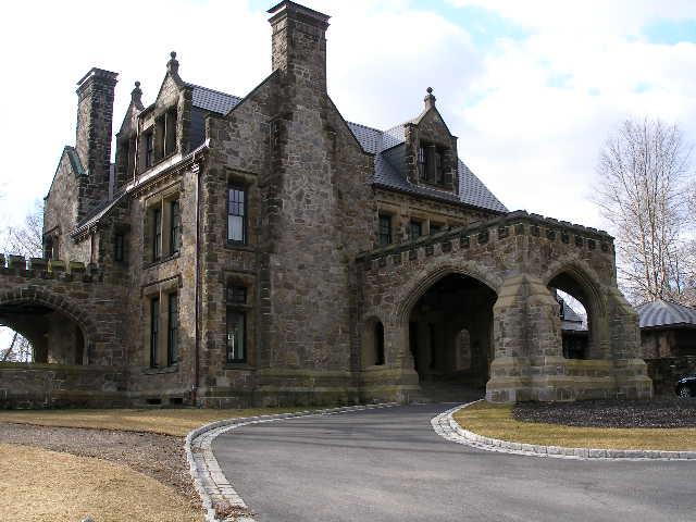
Historic name:
GreystoneCommon name:
White, Jonathan H. HouseNeighborhood:
Fisher HillArchitect(s):
Peabody and StearnsStyle(s):
English RevivalUse(s):
Business Office; College or University; Other Educational; Other Religious; Private School; Public School; Single Family Dwelling HouseSignificance(s):
ArchitectureDesignation(s):
Nat'l Register District (10/17/1985); Nat'l Register MRA (10/17/1985)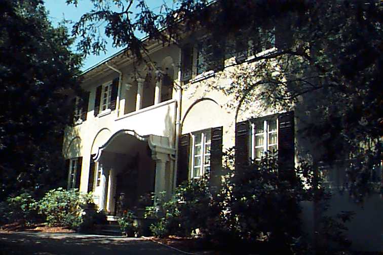
39 Clyde St
Built:
1910Class:
Single Family HouseLand area:
81,358 sfFAR:
0.10Owner:
Dexaie Properties LLCFY24:
$7,449,300 Δ8.71%| FY | Assessed | Change |
| 24 | $7,449,300 | 8.71% |
| 23 | $6,852,400 | 5.00% |
| 22 | $6,525,900 | 4.58% |
| 21 | $6,240,200 | 6.81% |
| 20 | $5,842,100 | 5.00% |
| 19 | $5,563,900 | 3.24% |
| 18 | $5,389,100 | 6.00% |
| 17 | $5,083,900 | 7.48% |
| 16 | $4,730,100 | 7.00% |
| 15 | $4,420,700 | 9.01% |
| 14 | $4,055,500 | 3.00% |
| 13 | $3,937,400 | 0.00% |
| 12 | $3,937,400 | 6.89% |
| 11 | $3,683,700 | 0.03% |
| 10 | $3,682,700 | 0.00% |
| 09 | $3,682,700 | -3.29% |
| 08 | $3,808,000 | -4.11% |
| 07 | $3,971,400 | 0.00% |
| 06 | $3,971,400 | 10.53% |
| 05 | $3,593,200 | 7.00% |
| 04 | $3,358,200 | 10.52% |
| 03 | $3,038,600 | 33.91% |
| 02 | $2,269,100 |
Historic name:
Washburn, Gardner HouseNeighborhood:
Heath - Warren EstatesArchitect(s):
Brown, Frank ChouteauStyle(s):
Spanish EclecticUse(s):
Single Family Dwelling HouseSignificance(s):
Architecture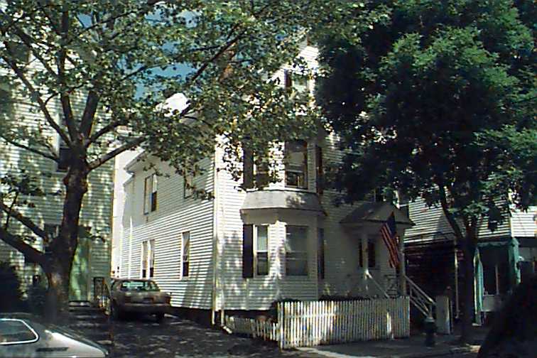
15 Kendall St
Built:
1900Class:
Two-Family HouseLand area:
2,196 sfFAR:
1.10Owner:
Angel & Marilyn EstradaFY24:
$963,900 Δ8.41%| FY | Assessed | Change |
| 24 | $963,900 | 8.41% |
| 23 | $889,100 | -20.02% |
| 22 | $1,111,700 | 4.00% |
| 21 | $1,068,900 | 2.20% |
| 20 | $1,045,900 | 5.00% |
| 19 | $996,100 | 10.84% |
| 18 | $898,700 | 8.00% |
| 17 | $832,100 | 9.99% |
| 16 | $756,500 | 10.00% |
| 15 | $687,700 | 11.31% |
| 14 | $617,800 | 5.00% |
| 13 | $588,400 | 0.00% |
| 12 | $588,400 | 0.27% |
| 11 | $586,800 | 0.00% |
| 10 | $586,800 | -0.05% |
| 09 | $587,100 | 7.12% |
| 08 | $548,100 | -2.18% |
| 07 | $560,300 | 0.04% |
| 06 | $560,100 | 6.85% |
| 05 | $524,200 | 7.00% |
| 04 | $489,900 | 9.99% |
| 03 | $445,400 | 25.71% |
| 02 | $354,300 |

191 Clyde St
Class:
Commercial with ResidentialLand area:
10,318,330 sfOwner:
Country Club, TheFY24:
$89,383,800 Δ10.07%| FY | Assessed | Change |
| 24 | $89,383,800 | 10.07% |
| 23 | $81,209,700 | 7.28% |
| 22 | $75,699,300 | 3.55% |
| 21 | $73,107,600 | 5.11% |
| 20 | $69,556,100 | 3.85% |
| 19 | $66,977,700 | 14.25% |
| 18 | $58,625,400 | 7.35% |
| 17 | $54,609,300 | 4.01% |
| 16 | $52,502,900 | 1.45% |
| 15 | $51,750,500 | 5.77% |
| 14 | $48,929,600 | 1.48% |
| 13 | $48,215,240 | -0.46% |
| 12 | $48,440,400 | 0.81% |
| 11 | $48,049,600 | 0.00% |
| 10 | $48,049,600 | -3.68% |
| 09 | $49,882,900 | 3.16% |
| 08 | $48,354,200 | 3.60% |
| 07 | $46,673,900 | 0.54% |
| 06 | $46,424,000 | 12.59% |
| 05 | $41,233,800 | 13.51% |
| 04 | $36,326,700 | 42.20% |
| 03 | $25,547,000 | -4.76% |
| 02 | $26,825,000 |
103 University Rd
Built:
1890Class:
Two-Family HouseLand area:
5,344 sfFAR:
0.65Owner:
Placeholder University Road II LLCFY24:
$2,292,000 Δ8.34%| FY | Assessed | Change |
| 24 | $2,292,000 | 8.34% |
| 23 | $2,115,500 | 5.00% |
| 22 | $2,014,800 | 4.00% |
| 21 | $1,937,300 | 2.24% |
| 20 | $1,894,800 | 5.00% |
| 19 | $1,804,500 | 13.62% |
| 18 | $1,588,200 | 8.01% |
| 17 | $1,470,400 | 10.00% |
| 16 | $1,336,700 | 14.28% |
| 15 | $1,169,700 | 8.68% |
| 14 | $1,076,300 | 5.00% |
| 13 | $1,025,000 | 0.00% |
| 12 | $1,025,000 | 1.18% |
| 11 | $1,013,000 | 0.00% |
| 10 | $1,013,000 | 0.00% |
| 09 | $1,013,000 | 8.68% |
| 08 | $932,100 | -2.37% |
| 07 | $954,700 | 0.00% |
| 06 | $954,700 | 4.53% |
| 05 | $913,300 | 6.99% |
| 04 | $853,600 | 11.19% |
| 03 | $767,700 | 25.09% |
| 02 | $613,700 |
97 University Rd
Built:
1900Class:
Two-Family HouseLand area:
6,873 sfFAR:
0.56Owner:
University Road I LLCFY24:
$2,234,200 Δ5.42%| FY | Assessed | Change |
| 24 | $2,234,200 | 5.42% |
| 23 | $2,119,400 | 5.00% |
| 22 | $2,018,400 | 4.00% |
| 21 | $1,940,800 | 2.57% |
| 20 | $1,892,100 | 5.00% |
| 19 | $1,802,000 | 12.11% |
| 18 | $1,607,400 | 8.00% |
| 17 | $1,488,300 | 10.00% |
| 16 | $1,353,000 | 15.79% |
| 15 | $1,168,500 | 10.48% |
| 14 | $1,057,700 | 5.00% |
| 13 | $1,007,300 | 0.00% |
| 12 | $1,007,300 | 1.64% |
| 11 | $991,000 | -0.33% |
| 10 | $994,300 | 0.00% |
| 09 | $994,300 | -2.71% |
| 08 | $1,022,000 | -2.00% |
| 07 | $1,042,900 | 0.59% |
| 06 | $1,036,800 | 7.84% |
| 05 | $961,400 | 6.99% |
| 04 | $898,600 | 10.01% |
| 03 | $816,800 | 19.17% |
| 02 | $685,400 |
25 Brington Rd
Built:
1928Class:
Two-Family HouseLand area:
11,886 sfFAR:
0.25Owner:
David Harelick; Jordana WerbaFY24:
$1,479,800 Δ4.41%| FY | Assessed | Change |
| 24 | $1,479,800 | 4.41% |
| 23 | $1,417,300 | -15.23% |
| 22 | $1,671,900 | -11.70% |
| 21 | $1,893,400 | 2.68% |
| 20 | $1,843,900 | 5.00% |
| 19 | $1,756,100 | 12.70% |
| 18 | $1,558,200 | 8.01% |
| 17 | $1,442,700 | 10.00% |
| 16 | $1,311,500 | 10.01% |
| 15 | $1,192,200 | 7.97% |
| 14 | $1,104,200 | 5.00% |
| 13 | $1,051,600 | 0.00% |
| 12 | $1,051,600 | 1.32% |
| 11 | $1,037,900 | 0.00% |
| 10 | $1,037,900 | 0.04% |
| 09 | $1,037,500 | 0.21% |
| 08 | $1,035,300 | 9.13% |
| 07 | $948,700 | 0.00% |
| 06 | $948,700 | 11.81% |
| 05 | $848,500 | 7.00% |
| 04 | $793,000 | 10.00% |
| 03 | $720,900 | 28.39% |
| 02 | $561,500 |
Demolition delayed to:
2024-02-14garage, house under separate delay
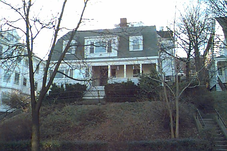
124 Coolidge St
Built:
1900Class:
Single Family HouseLand area:
5,222 sfFAR:
0.51Owner:
124 Coolidge Street Development LLCFY24:
$1,835,300 Δ4.19%| FY | Assessed | Change |
| 24 | $1,835,300 | 4.19% |
| 23 | $1,761,500 | 5.00% |
| 22 | $1,677,600 | 4.00% |
| 21 | $1,613,100 | 6.65% |
| 20 | $1,512,500 | 5.01% |
| 19 | $1,440,400 | 12.09% |
| 18 | $1,285,000 | 6.00% |
| 17 | $1,212,300 | 7.00% |
| 16 | $1,133,000 | 7.00% |
| 15 | $1,058,900 | 13.22% |
| 14 | $935,300 | 3.00% |
| 13 | $908,100 | 0.00% |
| 12 | $908,100 | 0.79% |
| 11 | $901,000 | 0.00% |
| 10 | $901,000 | 0.01% |
| 09 | $900,900 | 1.16% |
| 08 | $890,600 | -4.00% |
| 07 | $927,700 | -0.01% |
| 06 | $927,800 | 22.13% |
| 05 | $759,700 | 7.02% |
| 04 | $709,900 | 9.99% |
| 03 | $645,400 | 5.49% |
| 02 | $611,800 |
103 Colbourne Cres
Built:
1915Class:
Two-Family HouseLand area:
5,527 sfFAR:
0.71Owner:
Aaron M Adler TrFY24:
$2,186,800 Δ4.98%| FY | Assessed | Change |
| 24 | $2,186,800 | 4.98% |
| 23 | $2,083,100 | 5.00% |
| 22 | $1,983,900 | 4.00% |
| 21 | $1,907,600 | 2.36% |
| 20 | $1,863,700 | 5.00% |
| 19 | $1,775,000 | 12.80% |
| 18 | $1,573,600 | 8.00% |
| 17 | $1,457,100 | 10.00% |
| 16 | $1,324,600 | 14.57% |
| 15 | $1,156,200 | 12.01% |
| 14 | $1,032,200 | 5.01% |
| 13 | $983,000 | 0.00% |
| 12 | $983,000 | 2.82% |
| 11 | $956,000 | 0.00% |
| 10 | $956,000 | 0.00% |
| 09 | $956,000 | -0.53% |
| 08 | $961,100 | -2.00% |
| 07 | $980,700 | 0.00% |
| 06 | $980,700 | 8.22% |
| 05 | $906,200 | 7.00% |
| 04 | $846,900 | 10.00% |
| 03 | $769,900 | 22.42% |
| 02 | $628,900 |
Historic name:
Kinney, John F. HouseNeighborhood:
Aspinwall HillArchitect(s):
Foley, John C.Style(s):
Colonial Revival; Shingle StyleUse(s):
Multiple Family Dwelling HouseSignificance(s):
Architecture
124 Coolidge St
Built:
1900Class:
Single Family HouseLand area:
5,222 sfFAR:
0.51Owner:
124 Coolidge Street Development LLCFY24:
$1,835,300 Δ4.19%| FY | Assessed | Change |
| 24 | $1,835,300 | 4.19% |
| 23 | $1,761,500 | 5.00% |
| 22 | $1,677,600 | 4.00% |
| 21 | $1,613,100 | 6.65% |
| 20 | $1,512,500 | 5.01% |
| 19 | $1,440,400 | 12.09% |
| 18 | $1,285,000 | 6.00% |
| 17 | $1,212,300 | 7.00% |
| 16 | $1,133,000 | 7.00% |
| 15 | $1,058,900 | 13.22% |
| 14 | $935,300 | 3.00% |
| 13 | $908,100 | 0.00% |
| 12 | $908,100 | 0.79% |
| 11 | $901,000 | 0.00% |
| 10 | $901,000 | 0.01% |
| 09 | $900,900 | 1.16% |
| 08 | $890,600 | -4.00% |
| 07 | $927,700 | -0.01% |
| 06 | $927,800 | 22.13% |
| 05 | $759,700 | 7.02% |
| 04 | $709,900 | 9.99% |
| 03 | $645,400 | 5.49% |
| 02 | $611,800 |
59 Mason Ter
Built:
1900Class:
Two-Family HouseLand area:
8,390 sfFAR:
0.37Owner:
59-61 Mason Terrace LLCFY24:
$2,113,800 Δ5.12%| FY | Assessed | Change |
| 24 | $2,113,800 | 5.12% |
| 23 | $2,010,900 | 5.00% |
| 22 | $1,915,100 | 4.00% |
| 21 | $1,841,500 | 6.48% |
| 20 | $1,729,500 | 5.00% |
| 19 | $1,647,200 | 10.65% |
| 18 | $1,488,700 | 8.01% |
| 17 | $1,378,300 | 10.00% |
| 16 | $1,253,000 | 21.06% |
| 15 | $1,035,000 | 11.06% |
| 14 | $931,900 | 5.00% |
| 13 | $887,500 | 0.00% |
| 12 | $887,500 | 1.77% |
| 11 | $872,100 | 0.00% |
| 10 | $872,100 | 0.00% |
| 09 | $872,100 | 2.70% |
| 08 | $849,200 | -2.00% |
| 07 | $866,500 | 0.00% |
| 06 | $866,500 | 11.33% |
| 05 | $778,300 | 7.00% |
| 04 | $727,400 | 10.01% |
| 03 | $661,200 | 17.46% |
| 02 | $562,900 |
2 Claflin Rd
Units:
22Class:
Nine or More Unit ApartmentLand area:
11,870 sfOwner:
Tri Corner Realty LLC; C/O Jeff KleinFY24:
$9,652,500 Δ3.37%| FY | Assessed | Change |
| 24 | $9,652,500 | 3.37% |
| 23 | $9,337,400 | 9.16% |
| 22 | $8,553,600 | -0.55% |
| 21 | $8,600,700 | 3.82% |
| 20 | $8,284,400 | 9.38% |
| 19 | $7,573,700 | 17.59% |
| 18 | $6,440,600 | 7.44% |
| 17 | $5,994,600 | 8.78% |
| 16 | $5,511,000 | 7.58% |
| 15 | $5,122,800 | 27.58% |
| 14 | $4,015,400 | 5.31% |
| 13 | $3,813,000 | 1.86% |
| 12 | $3,743,500 | 0.91% |
| 11 | $3,709,700 | 1.03% |
| 10 | $3,671,800 | 0.28% |
| 09 | $3,661,500 | 17.19% |
| 08 | $3,124,400 | 8.34% |
| 07 | $2,884,000 | 0.73% |
| 06 | $2,863,000 | -9.14% |
| 05 | $3,151,000 | 8.36% |
| 04 | $2,908,000 | 9.86% |
| 03 | $2,647,000 | 44.17% |
| 02 | $1,836,000 |

50 School St
Built:
1855Class:
Municipal EducationLand area:
138,055 sfOwner:
Town Of Brookline; C/O Pierce SchoolFY24:
$43,042,700 Δ0.99%| FY | Assessed | Change |
| 24 | $43,042,700 | 0.99% |
| 23 | $42,619,100 | 3.33% |
| 22 | $41,246,500 | -1.09% |
| 21 | $41,701,500 | -1.95% |
| 20 | $42,529,900 | 2.30% |
| 19 | $41,573,100 | 18.18% |
| 18 | $35,178,900 | -2.07% |
| 17 | $35,924,200 | 23.80% |
| 16 | $29,017,600 | -10.45% |
| 15 | $32,402,900 | -17.77% |
| 14 | $39,406,500 | 16.37% |
| 13 | $33,864,400 | 0.00% |
| 12 | $33,864,400 | 32.32% |
| 11 | $25,592,700 | 0.00% |
| 10 | $25,592,700 | 56.12% |
| 09 | $16,392,500 | -43.63% |
| 08 | $29,080,000 | 0.00% |
| 07 | $29,080,000 | 0.00% |
| 06 | $29,080,000 | 7.28% |
| 05 | $27,107,000 | 17.70% |
| 04 | $23,030,700 | 0.00% |
| 03 | $23,030,700 | 13.80% |
| 02 | $20,237,200 |
Historic name:
Pierce SchoolNeighborhood:
Brookline Village; Civic CenterArchitect(s):
Schweinfurth, Julius AdolpheStyle(s):
Colonial RevivalUse(s):
Public SchoolSignificance(s):
Architecture; EducationDesignation(s):
Nat'l Register District (5/22/1979)
11 Goodwin Pl
Built:
1880Class:
Single Family HouseLand area:
7,500 sfFAR:
0.39Owner:
11-12 Goodwin Place LLCFY24:
$1,873,000 Δ9.21%| FY | Assessed | Change |
| 24 | $1,873,000 | 9.21% |
| 23 | $1,715,100 | 5.00% |
| 22 | $1,633,400 | 4.00% |
| 21 | $1,570,600 | 6.33% |
| 20 | $1,477,100 | 5.00% |
| 19 | $1,406,700 | 6.32% |
| 18 | $1,323,100 | 6.00% |
| 17 | $1,248,200 | 7.00% |
| 16 | $1,166,500 | 7.00% |
| 15 | $1,090,200 | 8.33% |
| 14 | $1,006,400 | 3.00% |
| 13 | $977,100 | -2.07% |
| 12 | $997,800 | 6.31% |
| 11 | $938,600 | 1.58% |
| 10 | $924,000 | 0.00% |
| 09 | $924,000 | 0.34% |
| 08 | $920,900 | -4.00% |
| 07 | $959,300 | 0.02% |
| 06 | $959,100 | 27.17% |
| 05 | $754,200 | 7.01% |
| 04 | $704,800 | 9.99% |
| 03 | $640,800 | 12.48% |
| 02 | $569,700 |

12 Goodwin Pl
Built:
1880Units:
3Class:
Two-Family HouseLand area:
7,300 sfFAR:
0.40Owner:
11-12 Goodwin Place LLCFY24:
$1,898,800 Δ6.92%| FY | Assessed | Change |
| 24 | $1,898,800 | 6.92% |
| 23 | $1,775,900 | 5.00% |
| 22 | $1,691,400 | 4.00% |
| 21 | $1,626,300 | 3.57% |
| 20 | $1,570,200 | 5.00% |
| 19 | $1,495,400 | 6.64% |
| 18 | $1,402,300 | 7.99% |
| 17 | $1,298,500 | 10.01% |
| 16 | $1,180,400 | 10.00% |
| 15 | $1,073,100 | 10.06% |
| 14 | $975,000 | 5.00% |
| 13 | $928,600 | 0.00% |
| 12 | $928,600 | 1.08% |
| 11 | $918,700 | -0.01% |
| 10 | $918,800 | 0.00% |
| 09 | $918,800 | -0.22% |
| 08 | $920,800 | -2.00% |
| 07 | $939,600 | -0.30% |
| 06 | $942,400 | 20.81% |
| 05 | $780,100 | 6.99% |
| 04 | $729,100 | 10.00% |
| 03 | $662,800 | 13.77% |
| 02 | $582,600 |
Demolition delayed to:
2023-10-11garage only, house not endangered
750 Washington St
Built:
1900Class:
Single Family HouseLand area:
7,803 sfFAR:
0.29Owner:
Brendan M & Janine Burman Gage TrsFY24:
$1,844,300 Δ10.04%| FY | Assessed | Change |
| 24 | $1,844,300 | 10.04% |
| 23 | $1,676,000 | 5.00% |
| 22 | $1,596,200 | 4.00% |
| 21 | $1,534,800 | 7.35% |
| 20 | $1,429,700 | 5.00% |
| 19 | $1,361,600 | 29.47% |
| 18 | $1,051,700 | 6.00% |
| 17 | $992,200 | 19.15% |
| 16 | $832,700 | 7.00% |
| 15 | $778,200 | 6.59% |
| 14 | $730,100 | 3.01% |
| 13 | $708,800 | 0.00% |
| 12 | $708,800 | 4.67% |
| 11 | $677,200 | 0.00% |
| 10 | $677,200 | 0.00% |
| 09 | $677,200 | -1.94% |
| 08 | $690,600 | -4.00% |
| 07 | $719,400 | 0.00% |
| 06 | $719,400 | 5.67% |
| 05 | $680,800 | 7.01% |
| 04 | $636,200 | 9.99% |
| 03 | $578,400 | 14.22% |
| 02 | $506,400 |

202 Mason Ter
Built:
1923Units:
2Class:
Single Family HouseLand area:
12,104 sfFAR:
0.22Owner:
Yuan Zhao & Anne E GaoFY24:
$2,141,700 Δ7.95%| FY | Assessed | Change |
| 24 | $2,141,700 | 7.95% |
| 23 | $1,983,900 | 5.00% |
| 22 | $1,889,400 | 4.00% |
| 21 | $1,816,700 | 9.85% |
| 20 | $1,653,800 | 5.00% |
| 19 | $1,575,000 | 11.36% |
| 18 | $1,414,300 | 6.00% |
| 17 | $1,334,300 | 7.00% |
| 16 | $1,247,000 | 17.76% |
| 15 | $1,058,900 | 7.97% |
| 14 | $980,700 | 3.00% |
| 13 | $952,100 | 0.00% |
| 12 | $952,100 | 3.35% |
| 11 | $921,200 | -0.10% |
| 10 | $922,100 | 1.95% |
| 09 | $904,500 | 0.65% |
| 08 | $898,700 | -4.00% |
| 07 | $936,100 | 0.00% |
| 06 | $936,100 | 16.95% |
| 05 | $800,400 | 7.01% |
| 04 | $748,000 | 10.00% |
| 03 | $680,000 | 5.87% |
| 02 | $642,300 |

15 Glenland Rd
Built:
1915Class:
Two-Family HouseLand area:
3,139 sfFAR:
0.63Owner:
Glenland Road Partners LLCFY24:
$944,100 Δ6.75%| FY | Assessed | Change |
| 24 | $944,100 | 6.75% |
| 23 | $884,400 | 4.99% |
| 22 | $842,400 | 4.00% |
| 21 | $810,000 | 1.84% |
| 20 | $795,400 | 5.00% |
| 19 | $757,500 | 3.72% |
| 18 | $730,300 | 7.95% |
| 17 | $676,500 | 9.95% |
| 16 | $615,300 | 9.93% |
| 15 | $559,700 | 10.31% |
| 14 | $507,400 | 4.96% |
| 13 | $483,400 | -0.74% |
| 12 | $487,000 | 1.42% |
| 11 | $480,200 | 0.00% |
| 10 | $480,200 | 0.00% |
| 09 | $480,200 | 6.78% |
| 08 | $449,700 | -2.00% |
| 07 | $458,900 | 0.00% |
| 06 | $458,900 | 6.35% |
| 05 | $431,500 | 6.99% |
| 04 | $403,300 | 9.98% |
| 03 | $366,700 | 20.07% |
| 02 | $305,400 |
Historic name:
Mahoney, Edward HouseNeighborhood:
HolyhoodArchitect(s):
Gowing, Frederick H.Style(s):
Colonial RevivalUse(s):
Multiple Family Dwelling HouseSignificance(s):
ArchitectureDemolition delayed to:
2024-03-13partial demolition, National Register district
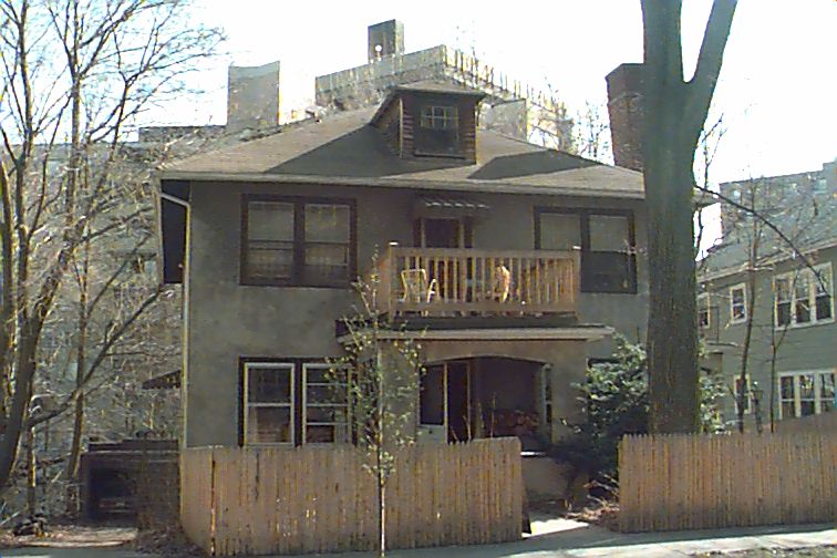
476 Heath St
Built:
1899Class:
Single Family HouseLand area:
18,438 sfFAR:
0.30Owner:
Jon RotenbergFY24:
$2,705,400 Δ4.87%| FY | Assessed | Change |
| 24 | $2,705,400 | 4.87% |
| 23 | $2,579,800 | 5.00% |
| 22 | $2,456,900 | 4.00% |
| 21 | $2,362,500 | 4.65% |
| 20 | $2,257,600 | 5.00% |
| 19 | $2,150,100 | -5.48% |
| 18 | $2,274,800 | 6.00% |
| 17 | $2,146,000 | 7.00% |
| 16 | $2,005,600 | 6.91% |
| 15 | $1,875,900 | 11.03% |
| 14 | $1,689,500 | 3.00% |
| 13 | $1,640,300 | 0.00% |
| 12 | $1,640,300 | 11.27% |
| 11 | $1,474,200 | 0.00% |
| 10 | $1,474,200 | 0.33% |
| 09 | $1,469,400 | -4.85% |
| 08 | $1,544,300 | -4.00% |
| 07 | $1,608,600 | 0.00% |
| 06 | $1,608,600 | 8.43% |
| 05 | $1,483,500 | 7.00% |
| 04 | $1,386,400 | 10.00% |
| 03 | $1,260,400 | 5.26% |
| 02 | $1,197,400 |
Historic name:
Bates, Benjamin E. HouseNeighborhood:
Chestnut HillArchitect(s):
Chapman and FrazerStyle(s):
English RevivalUse(s):
Multiple Family Dwelling House; Single Family Dwelling HouseSignificance(s):
ArchitectureDesignation(s):
Nat'l Register District (10/17/1985); Nat'l Register MRA (10/17/1985)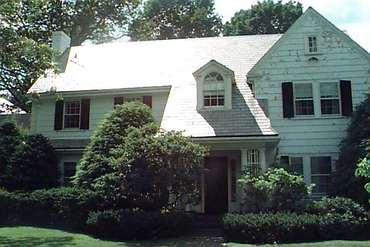
68 Clyde St
Built:
1910Class:
Single Family HouseLand area:
32,095 sfFAR:
0.14Owner:
Clyde Street Partners LLCFY24:
$3,674,600 Δ27.28%| FY | Assessed | Change |
| 24 | $3,674,600 | 27.28% |
| 23 | $2,887,000 | 5.00% |
| 22 | $2,749,400 | 4.00% |
| 21 | $2,643,700 | 6.68% |
| 20 | $2,478,200 | 5.00% |
| 19 | $2,360,200 | 7.07% |
| 18 | $2,204,300 | 6.00% |
| 17 | $2,079,500 | 7.00% |
| 16 | $1,943,400 | 6.89% |
| 15 | $1,818,100 | 6.96% |
| 14 | $1,699,800 | 3.00% |
| 13 | $1,650,300 | 0.00% |
| 12 | $1,650,300 | 9.94% |
| 11 | $1,501,100 | 0.00% |
| 10 | $1,501,100 | 0.14% |
| 09 | $1,499,000 | -4.74% |
| 08 | $1,573,600 | -4.22% |
| 07 | $1,643,000 | 0.00% |
| 06 | $1,643,000 | 9.13% |
| 05 | $1,505,600 | 6.99% |
| 04 | $1,407,200 | 10.01% |
| 03 | $1,279,200 | 25.46% |
| 02 | $1,019,600 |

38-A Stedman St
Built:
1898Class:
Single Family HouseLand area:
6,500 sfFAR:
0.49Owner:
38 Stedman Street Development LLCFY24:
$2,284,500 Δ5.53%| FY | Assessed | Change |
| 24 | $2,284,500 | 5.53% |
| 23 | $2,164,800 | 5.63% |
| 22 | $2,049,500 | 4.00% |
| 21 | $1,970,700 | 5.90% |
| 20 | $1,860,900 | 5.00% |
| 19 | $1,772,300 | 10.21% |
| 18 | $1,608,100 | 5.96% |
| 17 | $1,517,600 | 7.00% |
| 16 | $1,418,300 | 7.00% |
| 15 | $1,325,500 | 10.08% |
| 14 | $1,204,100 | 3.00% |
| 13 | $1,169,000 | 0.00% |
| 12 | $1,169,000 | 1.13% |
| 11 | $1,155,900 | 0.00% |
| 10 | $1,155,900 | -0.01% |
| 09 | $1,156,000 | 4.41% |
| 08 | $1,107,200 | -4.00% |
| 07 | $1,153,300 | 0.23% |
| 06 | $1,150,600 | 18.10% |
| 05 | $974,300 | 7.00% |
| 04 | $910,600 | 10.00% |
| 03 | $827,800 | 16.22% |
| 02 | $712,300 |
Historic name:
Peterson, Millard HouseNeighborhood:
North BrooklineArchitect(s):
Carrigan, JohnStyle(s):
CraftsmanUse(s):
Multiple Family Dwelling House; Single Family Dwelling HouseSignificance(s):
Architecture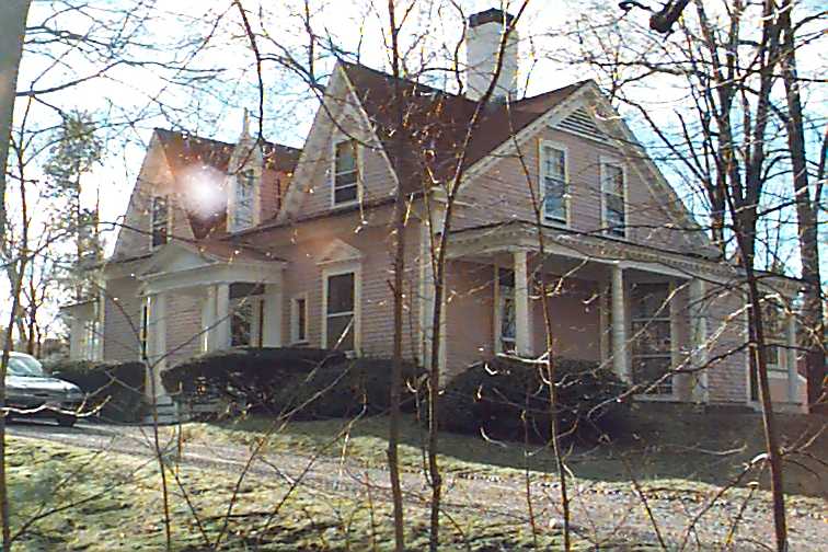
61 Heath St
Built:
1824Class:
Single Family HouseLand area:
41,305 sfFAR:
0.09Owner:
William B Jr & Pamela R HoldingFY24:
$2,900,700 Δ-2.52%| FY | Assessed | Change |
| 24 | $2,900,700 | -2.52% |
| 23 | $2,975,600 | 5.00% |
| 22 | $2,833,900 | 4.00% |
| 21 | $2,724,900 | 6.79% |
| 20 | $2,551,700 | 5.00% |
| 19 | $2,430,200 | -1.36% |
| 18 | $2,463,600 | 6.01% |
| 17 | $2,324,000 | 7.00% |
| 16 | $2,172,000 | 7.00% |
| 15 | $2,029,900 | 8.52% |
| 14 | $1,870,500 | 3.00% |
| 13 | $1,816,000 | -1.48% |
| 12 | $1,843,300 | 6.90% |
| 11 | $1,724,300 | 0.03% |
| 10 | $1,723,800 | -0.02% |
| 09 | $1,724,200 | -3.70% |
| 08 | $1,790,500 | -4.21% |
| 07 | $1,869,200 | 0.32% |
| 06 | $1,863,300 | 4.68% |
| 05 | $1,780,000 | 7.00% |
| 04 | $1,663,600 | 10.00% |
| 03 | $1,512,300 | 28.97% |
| 02 | $1,172,600 |
Historic name:
Elliot, Gen. Simon HouseNeighborhood:
Heath - Warren EstatesStyle(s):
Greek RevivalUse(s):
Single Family Dwelling HouseSignificance(s):
ArchitectureDesignation(s):
Nat'l Register Individual Property (10/17/1985); Nat'l Register MRA (10/17/1985)Click on the map or address list to view building info.
Address (MHC ID)
- 212 Aspinwall Ave (544)
- 66 Toxteth St (567)
- 111 University Rd (717)
- 134 Clinton Rd (797)
- 41 Codman Rd
- 244 Heath St
- 12 Naples Rd (239)
- 18 Williston Rd (393)
- 70 Francis St
- 71 Green St
- 30 Stetson St (137)
- 47 University Rd
- 100 Woodcliff Rd (3353)
- 12 Williams St
- 12 Thayer St (2995)
- 45 Warren St (1227)
- 62 Buckminster Rd (1546)
- 39 Clyde St (1391)
- 15 Kendall St
- 191 Clyde St
- 103 University Rd
- 97 University Rd
- 25 Brington Rd
- 124 Coolidge St
- 103 Colbourne Cres (757)
- 124 Coolidge St
- 59 Mason Ter
- 2 Claflin Rd
- 50 School St (645)
- 11 Goodwin Pl
- 12 Goodwin Pl
- 750 Washington St
- 202 Mason Ter
- 15 Glenland Rd (1338)
- 476 Heath St (1593)
- 68 Clyde St
- 38-A Stedman St (196)
- 61 Heath St (1738)