Endangered
An application has been made to demolish or significantly alter these buildings.
If a property is deemed to have historic merit, the Town has the option of placing a stay of demolition for up to 12 months — or 18 months for National Register properties — to allow the Town and the owner to discuss alternatives to demolition of the property.

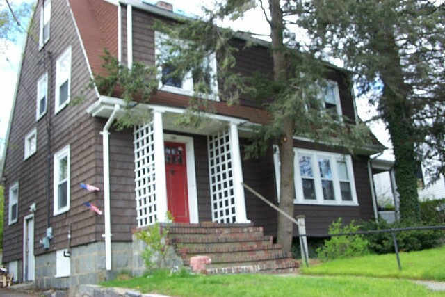
12 Goodwin Pl
Built:
1880Units:
3Class:
Two-Family HouseLand area:
7,300 sfFAR:
0.40Owner:
11-12 Goodwin Place LLCFY24:
$1,898,800 Δ6.92%| FY | Assessed | Change |
| 24 | $1,898,800 | 6.92% |
| 23 | $1,775,900 | 5.00% |
| 22 | $1,691,400 | 4.00% |
| 21 | $1,626,300 | 3.57% |
| 20 | $1,570,200 | 5.00% |
| 19 | $1,495,400 | 6.64% |
| 18 | $1,402,300 | 7.99% |
| 17 | $1,298,500 | 10.01% |
| 16 | $1,180,400 | 10.00% |
| 15 | $1,073,100 | 10.06% |
| 14 | $975,000 | 5.00% |
| 13 | $928,600 | 0.00% |
| 12 | $928,600 | 1.08% |
| 11 | $918,700 | -0.01% |
| 10 | $918,800 | 0.00% |
| 09 | $918,800 | -0.22% |
| 08 | $920,800 | -2.00% |
| 07 | $939,600 | -0.30% |
| 06 | $942,400 | 20.81% |
| 05 | $780,100 | 6.99% |
| 04 | $729,100 | 10.00% |
| 03 | $662,800 | 13.77% |
| 02 | $582,600 |
Demolition delayed to:
2023-10-11garage only, house not endangered
750 Washington St
Built:
1900Class:
Single Family HouseLand area:
7,803 sfFAR:
0.29Owner:
Brendan M & Janine Burman Gage TrsFY24:
$1,844,300 Δ10.04%| FY | Assessed | Change |
| 24 | $1,844,300 | 10.04% |
| 23 | $1,676,000 | 5.00% |
| 22 | $1,596,200 | 4.00% |
| 21 | $1,534,800 | 7.35% |
| 20 | $1,429,700 | 5.00% |
| 19 | $1,361,600 | 29.47% |
| 18 | $1,051,700 | 6.00% |
| 17 | $992,200 | 19.15% |
| 16 | $832,700 | 7.00% |
| 15 | $778,200 | 6.59% |
| 14 | $730,100 | 3.01% |
| 13 | $708,800 | 0.00% |
| 12 | $708,800 | 4.67% |
| 11 | $677,200 | 0.00% |
| 10 | $677,200 | 0.00% |
| 09 | $677,200 | -1.94% |
| 08 | $690,600 | -4.00% |
| 07 | $719,400 | 0.00% |
| 06 | $719,400 | 5.67% |
| 05 | $680,800 | 7.01% |
| 04 | $636,200 | 9.99% |
| 03 | $578,400 | 14.22% |
| 02 | $506,400 |

202 Mason Ter
Built:
1923Units:
2Class:
Single Family HouseLand area:
12,104 sfFAR:
0.22Owner:
Yuan Zhao & Anne E GaoFY24:
$2,141,700 Δ7.95%| FY | Assessed | Change |
| 24 | $2,141,700 | 7.95% |
| 23 | $1,983,900 | 5.00% |
| 22 | $1,889,400 | 4.00% |
| 21 | $1,816,700 | 9.85% |
| 20 | $1,653,800 | 5.00% |
| 19 | $1,575,000 | 11.36% |
| 18 | $1,414,300 | 6.00% |
| 17 | $1,334,300 | 7.00% |
| 16 | $1,247,000 | 17.76% |
| 15 | $1,058,900 | 7.97% |
| 14 | $980,700 | 3.00% |
| 13 | $952,100 | 0.00% |
| 12 | $952,100 | 3.35% |
| 11 | $921,200 | -0.10% |
| 10 | $922,100 | 1.95% |
| 09 | $904,500 | 0.65% |
| 08 | $898,700 | -4.00% |
| 07 | $936,100 | 0.00% |
| 06 | $936,100 | 16.95% |
| 05 | $800,400 | 7.01% |
| 04 | $748,000 | 10.00% |
| 03 | $680,000 | 5.87% |
| 02 | $642,300 |

15 Glenland Rd
Built:
1915Class:
Two-Family HouseLand area:
3,139 sfFAR:
0.63Owner:
Glenland Road Partners LLCFY24:
$944,100 Δ6.75%| FY | Assessed | Change |
| 24 | $944,100 | 6.75% |
| 23 | $884,400 | 4.99% |
| 22 | $842,400 | 4.00% |
| 21 | $810,000 | 1.84% |
| 20 | $795,400 | 5.00% |
| 19 | $757,500 | 3.72% |
| 18 | $730,300 | 7.95% |
| 17 | $676,500 | 9.95% |
| 16 | $615,300 | 9.93% |
| 15 | $559,700 | 10.31% |
| 14 | $507,400 | 4.96% |
| 13 | $483,400 | -0.74% |
| 12 | $487,000 | 1.42% |
| 11 | $480,200 | 0.00% |
| 10 | $480,200 | 0.00% |
| 09 | $480,200 | 6.78% |
| 08 | $449,700 | -2.00% |
| 07 | $458,900 | 0.00% |
| 06 | $458,900 | 6.35% |
| 05 | $431,500 | 6.99% |
| 04 | $403,300 | 9.98% |
| 03 | $366,700 | 20.07% |
| 02 | $305,400 |
Historic name:
Mahoney, Edward HouseNeighborhood:
HolyhoodArchitect(s):
Gowing, Frederick H.Style(s):
Colonial RevivalUse(s):
Multiple Family Dwelling HouseSignificance(s):
ArchitectureDemolition delayed to:
2024-03-13partial demolition, National Register district
476 Heath St
Built:
1899Class:
Single Family HouseLand area:
18,438 sfFAR:
0.30Owner:
Jon RotenbergFY24:
$2,705,400 Δ4.87%| FY | Assessed | Change |
| 24 | $2,705,400 | 4.87% |
| 23 | $2,579,800 | 5.00% |
| 22 | $2,456,900 | 4.00% |
| 21 | $2,362,500 | 4.65% |
| 20 | $2,257,600 | 5.00% |
| 19 | $2,150,100 | -5.48% |
| 18 | $2,274,800 | 6.00% |
| 17 | $2,146,000 | 7.00% |
| 16 | $2,005,600 | 6.91% |
| 15 | $1,875,900 | 11.03% |
| 14 | $1,689,500 | 3.00% |
| 13 | $1,640,300 | 0.00% |
| 12 | $1,640,300 | 11.27% |
| 11 | $1,474,200 | 0.00% |
| 10 | $1,474,200 | 0.33% |
| 09 | $1,469,400 | -4.85% |
| 08 | $1,544,300 | -4.00% |
| 07 | $1,608,600 | 0.00% |
| 06 | $1,608,600 | 8.43% |
| 05 | $1,483,500 | 7.00% |
| 04 | $1,386,400 | 10.00% |
| 03 | $1,260,400 | 5.26% |
| 02 | $1,197,400 |
Historic name:
Bates, Benjamin E. HouseNeighborhood:
Chestnut HillArchitect(s):
Chapman and FrazerStyle(s):
English RevivalUse(s):
Multiple Family Dwelling House; Single Family Dwelling HouseSignificance(s):
ArchitectureDesignation(s):
Nat'l Register District (10/17/1985); Nat'l Register MRA (10/17/1985)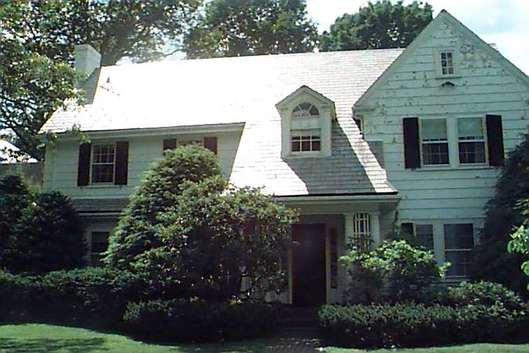
68 Clyde St
Built:
1910Class:
Single Family HouseLand area:
32,095 sfFAR:
0.14Owner:
Clyde Street Partners LLCFY24:
$3,674,600 Δ27.28%| FY | Assessed | Change |
| 24 | $3,674,600 | 27.28% |
| 23 | $2,887,000 | 5.00% |
| 22 | $2,749,400 | 4.00% |
| 21 | $2,643,700 | 6.68% |
| 20 | $2,478,200 | 5.00% |
| 19 | $2,360,200 | 7.07% |
| 18 | $2,204,300 | 6.00% |
| 17 | $2,079,500 | 7.00% |
| 16 | $1,943,400 | 6.89% |
| 15 | $1,818,100 | 6.96% |
| 14 | $1,699,800 | 3.00% |
| 13 | $1,650,300 | 0.00% |
| 12 | $1,650,300 | 9.94% |
| 11 | $1,501,100 | 0.00% |
| 10 | $1,501,100 | 0.14% |
| 09 | $1,499,000 | -4.74% |
| 08 | $1,573,600 | -4.22% |
| 07 | $1,643,000 | 0.00% |
| 06 | $1,643,000 | 9.13% |
| 05 | $1,505,600 | 6.99% |
| 04 | $1,407,200 | 10.01% |
| 03 | $1,279,200 | 25.46% |
| 02 | $1,019,600 |

38-A Stedman St
Built:
1898Class:
Single Family HouseLand area:
6,500 sfFAR:
0.49Owner:
38 Stedman Street Development LLCFY24:
$2,284,500 Δ5.53%| FY | Assessed | Change |
| 24 | $2,284,500 | 5.53% |
| 23 | $2,164,800 | 5.63% |
| 22 | $2,049,500 | 4.00% |
| 21 | $1,970,700 | 5.90% |
| 20 | $1,860,900 | 5.00% |
| 19 | $1,772,300 | 10.21% |
| 18 | $1,608,100 | 5.96% |
| 17 | $1,517,600 | 7.00% |
| 16 | $1,418,300 | 7.00% |
| 15 | $1,325,500 | 10.08% |
| 14 | $1,204,100 | 3.00% |
| 13 | $1,169,000 | 0.00% |
| 12 | $1,169,000 | 1.13% |
| 11 | $1,155,900 | 0.00% |
| 10 | $1,155,900 | -0.01% |
| 09 | $1,156,000 | 4.41% |
| 08 | $1,107,200 | -4.00% |
| 07 | $1,153,300 | 0.23% |
| 06 | $1,150,600 | 18.10% |
| 05 | $974,300 | 7.00% |
| 04 | $910,600 | 10.00% |
| 03 | $827,800 | 16.22% |
| 02 | $712,300 |
Historic name:
Peterson, Millard HouseNeighborhood:
North BrooklineArchitect(s):
Carrigan, JohnStyle(s):
CraftsmanUse(s):
Multiple Family Dwelling House; Single Family Dwelling HouseSignificance(s):
Architecture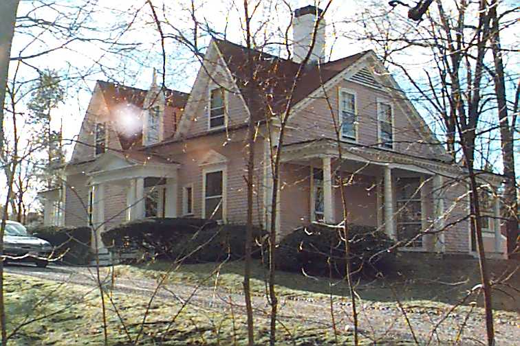
61 Heath St
Built:
1824Class:
Single Family HouseLand area:
41,305 sfFAR:
0.09Owner:
William B Jr & Pamela R HoldingFY24:
$2,900,700 Δ-2.52%| FY | Assessed | Change |
| 24 | $2,900,700 | -2.52% |
| 23 | $2,975,600 | 5.00% |
| 22 | $2,833,900 | 4.00% |
| 21 | $2,724,900 | 6.79% |
| 20 | $2,551,700 | 5.00% |
| 19 | $2,430,200 | -1.36% |
| 18 | $2,463,600 | 6.01% |
| 17 | $2,324,000 | 7.00% |
| 16 | $2,172,000 | 7.00% |
| 15 | $2,029,900 | 8.52% |
| 14 | $1,870,500 | 3.00% |
| 13 | $1,816,000 | -1.48% |
| 12 | $1,843,300 | 6.90% |
| 11 | $1,724,300 | 0.03% |
| 10 | $1,723,800 | -0.02% |
| 09 | $1,724,200 | -3.70% |
| 08 | $1,790,500 | -4.21% |
| 07 | $1,869,200 | 0.32% |
| 06 | $1,863,300 | 4.68% |
| 05 | $1,780,000 | 7.00% |
| 04 | $1,663,600 | 10.00% |
| 03 | $1,512,300 | 28.97% |
| 02 | $1,172,600 |
Historic name:
Elliot, Gen. Simon HouseNeighborhood:
Heath - Warren EstatesStyle(s):
Greek RevivalUse(s):
Single Family Dwelling HouseSignificance(s):
ArchitectureDesignation(s):
Nat'l Register Individual Property (10/17/1985); Nat'l Register MRA (10/17/1985)