Endangered
An application has been made to demolish or significantly alter these buildings.
If a property is deemed to have historic merit, the Town has the option of placing a stay of demolition for up to 12 months — or 18 months for National Register properties — to allow the Town and the owner to discuss alternatives to demolition of the property.
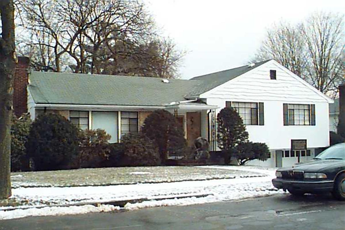
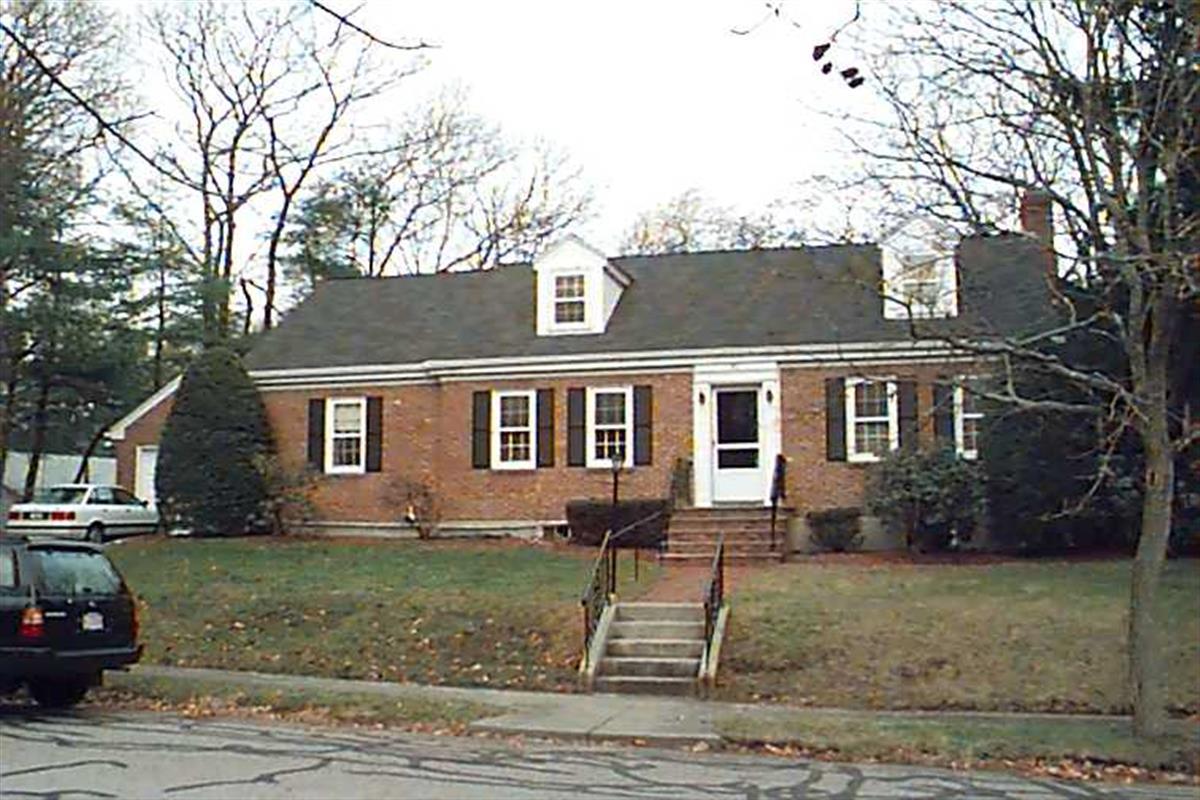
100 Woodcliff Rd
Built:
1954Class:
Single Family HouseLand area:
9,042 sfFAR:
0.17Owner:
100 Woodcliff LLCFY26:
$1,209,700 Δ5.51%| FY | Assessed | Change |
| 26 | $1,209,700 | 5.51% |
| 25 | $1,146,500 | 3.93% |
| 24 | $1,103,100 | 13.75% |
| 23 | $969,800 | 5.01% |
| 22 | $923,500 | 4.00% |
| 21 | $888,000 | 12.04% |
| 20 | $792,600 | 2.62% |
| 19 | $772,400 | 1.43% |
| 18 | $761,500 | 3.86% |
| 17 | $733,200 | 0.00% |
| 16 | $733,200 | 1.78% |
| 15 | $720,400 | 4.83% |
| 14 | $687,200 | 1.45% |
| 13 | $677,400 | 0.00% |
| 12 | $677,400 | 12.45% |
| 11 | $602,400 | 9.09% |
| 10 | $552,200 | 0.00% |
| 09 | $552,200 | 4.90% |
| 08 | $526,400 | -4.27% |
| 07 | $549,900 | -0.11% |
| 06 | $550,500 | 6.46% |
| 05 | $517,100 | 6.99% |
| 04 | $483,300 | 10.02% |
| 03 | $439,300 | -0.61% |
| 02 | $442,000 |
Historic name:
Silverman, Maurice HouseNeighborhood:
South Brookline; PutterhamArchitect(s):
Williams, Ralph I.Style(s):
Postwar Traditional; RanchUse(s):
Single Family Dwelling HouseSignificance(s):
Architecture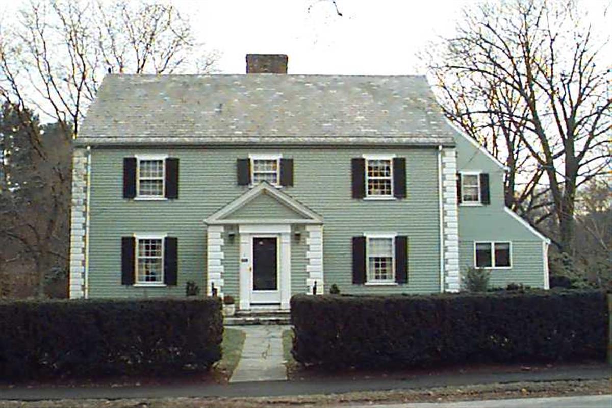
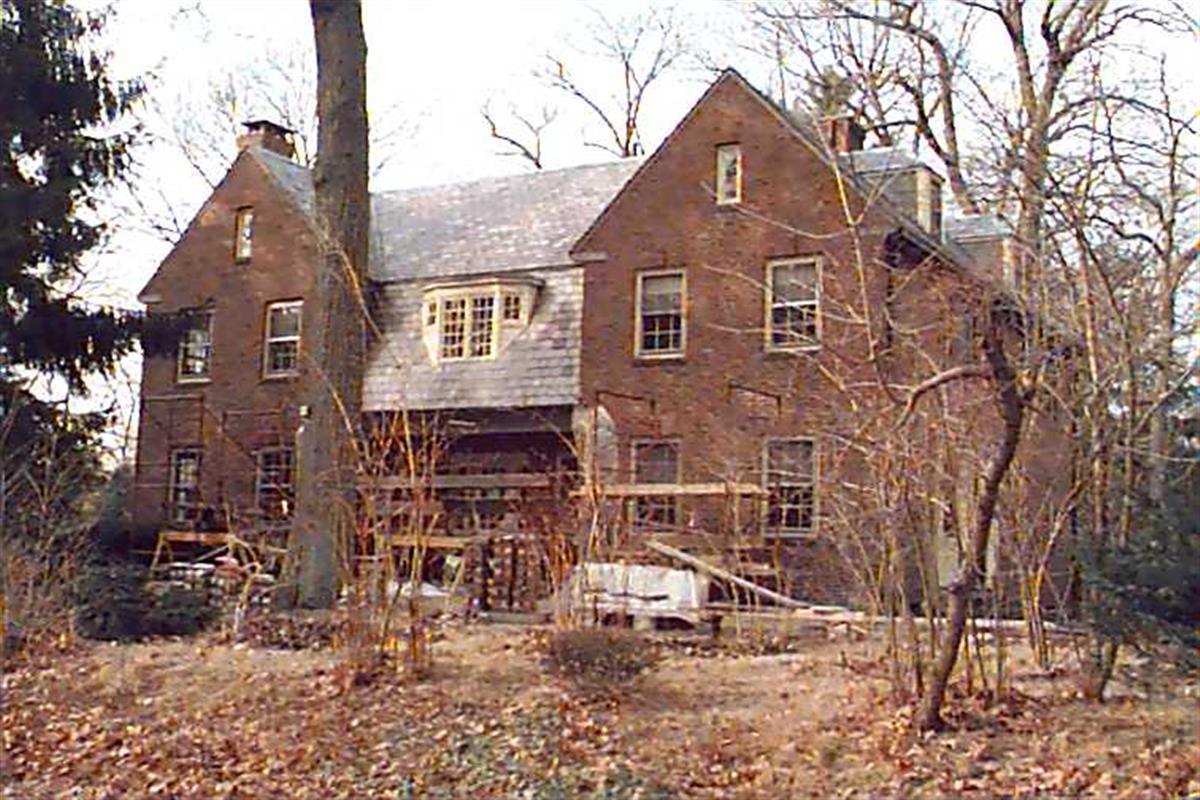
3 Glenoe Rd
Built:
1936Class:
Single Family HouseLand area:
17,583 sfFAR:
0.21Owner:
3 Glenoe Road LLCFY26:
$2,832,700 Δ-1.37%| FY | Assessed | Change |
| 26 | $2,832,700 | -1.37% |
| 25 | $2,872,100 | 3.77% |
| 24 | $2,767,800 | 11.22% |
| 23 | $2,488,500 | 5.00% |
| 22 | $2,370,100 | 4.01% |
| 21 | $2,278,800 | 4.98% |
| 20 | $2,170,800 | 5.00% |
| 19 | $2,067,400 | 1.24% |
| 18 | $2,042,000 | 6.00% |
| 17 | $1,926,500 | 7.00% |
| 16 | $1,800,500 | 7.01% |
| 15 | $1,682,600 | 1.94% |
| 14 | $1,650,500 | 3.00% |
| 13 | $1,602,400 | 0.00% |
| 12 | $1,602,400 | 6.56% |
| 11 | $1,503,700 | 0.00% |
| 10 | $1,503,700 | 0.36% |
| 09 | $1,498,300 | -0.43% |
| 08 | $1,504,800 | -4.00% |
| 07 | $1,567,500 | -0.01% |
| 06 | $1,567,600 | 13.41% |
| 05 | $1,382,200 | 7.00% |
| 04 | $1,291,800 | 10.00% |
| 03 | $1,174,400 | 17.16% |
| 02 | $1,002,400 |
Historic name:
McCarthy, Louis B. HouseNeighborhood:
WoodlandArchitect(s):
Jacobs, William NelsonStyle(s):
Colonial RevivalUse(s):
Single Family Dwelling HouseSignificance(s):
Architecture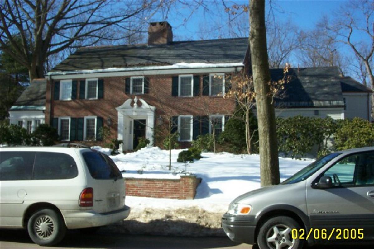
97 Laurel Rd
Built:
1937Class:
Single Family HouseLand area:
43,181 sfFAR:
0.11Owner:
Derek E & Elizabeth H TaffFY26:
$4,667,700 Δ0.47%| FY | Assessed | Change |
| 26 | $4,667,700 | 0.47% |
| 25 | $4,645,900 | 1.67% |
| 24 | $4,569,500 | 11.96% |
| 23 | $4,081,200 | 5.00% |
| 22 | $3,886,800 | -4.91% |
| 21 | $4,087,600 | 5.03% |
| 20 | $3,891,900 | 5.00% |
| 19 | $3,706,600 | -0.84% |
| 18 | $3,737,900 | 6.00% |
| 17 | $3,526,300 | 7.00% |
| 16 | $3,295,600 | 6.96% |
| 15 | $3,081,100 | 2.84% |
| 14 | $2,996,100 | 3.00% |
| 13 | $2,908,800 | 0.00% |
| 12 | $2,908,800 | 5.98% |
| 11 | $2,744,700 | 0.00% |
| 10 | $2,744,700 | -0.03% |
| 09 | $2,745,600 | 3.52% |
| 08 | $2,652,300 | -4.00% |
| 07 | $2,762,800 | -0.04% |
| 06 | $2,764,000 | 32.93% |
| 05 | $2,079,300 | 7.00% |
| 04 | $1,943,300 | 10.07% |
| 03 | $1,765,500 | 27.70% |
| 02 | $1,382,500 |
Historic name:
Pemberton, Dr. Frank A. HouseNeighborhood:
WoodlandArchitect(s):
Stowell, Raymond MilesStyle(s):
Colonial RevivalUse(s):
Single Family Dwelling HouseSignificance(s):
Architecture
100 Bellingham Rd
Built:
1942Class:
Religious PropertyLand area:
16,544 sfFAR:
0.15Owner:
Chabad Lubavitch Of Chestnut Hill IncFY26:
$1,500,700 Δ25.86%| FY | Assessed | Change |
| 26 | $1,500,700 | 25.86% |
| 25 | $1,192,400 | -9.99% |
| 24 | $1,324,700 | 10.17% |
| 23 | $1,202,400 | 5.00% |
| 22 | $1,145,100 | 4.00% |
| 21 | $1,101,100 | 5.92% |
| 20 | $1,039,600 | 4.99% |
| 19 | $990,200 | 4.07% |
| 18 | $951,500 | 6.00% |
| 17 | $897,600 | 7.00% |
| 16 | $838,900 | 9.70% |
| 15 | $764,700 | 7.09% |
| 14 | $714,100 | 3.00% |
| 13 | $693,300 | 0.00% |
| 12 | $693,300 | 3.68% |
| 11 | $668,700 | 0.00% |
| 10 | $668,700 | 0.00% |
| 09 | $668,700 | -1.43% |
| 08 | $678,400 | -3.25% |
| 07 | $701,200 | -0.79% |
| 06 | $706,800 | 12.96% |
| 05 | $625,700 | 6.99% |
| 04 | $584,800 | 10.01% |
| 03 | $531,600 | 7.05% |
| 02 | $496,600 |
90 Bellingham Rd
Built:
1949Class:
Religious PropertyLand area:
11,518 sfFAR:
0.17Owner:
Chabad Lubavitch Of Chestnut Hill IncFY26:
$1,388,200 Δ23.11%| FY | Assessed | Change |
| 26 | $1,388,200 | 23.11% |
| 25 | $1,127,600 | -8.13% |
| 24 | $1,227,400 | 11.01% |
| 23 | $1,105,700 | 4.99% |
| 22 | $1,053,100 | 4.00% |
| 21 | $1,012,600 | 6.15% |
| 20 | $953,900 | 5.01% |
| 19 | $908,400 | 1.59% |
| 18 | $894,200 | 6.00% |
| 17 | $843,600 | 11.63% |
| 16 | $755,700 | 6.99% |
| 15 | $706,300 | 7.88% |
| 14 | $654,700 | 3.01% |
| 13 | $635,600 | 0.00% |
| 12 | $635,600 | 0.03% |
| 11 | $635,400 | 0.00% |
| 10 | $635,400 | 0.00% |
| 09 | $635,400 | 5.83% |
| 08 | $600,400 | -4.00% |
| 07 | $625,400 | 0.00% |
| 06 | $625,400 | 7.25% |
| 05 | $583,100 | 6.99% |
| 04 | $545,000 | 10.01% |
| 03 | $495,400 | 7.32% |
| 02 | $461,600 |
145 Woodland Rd
Built:
1922Class:
Single Family HouseLand area:
27,387 sfFAR:
0.12Owner:
Louis B Harding 4ThFY26:
$2,980,400 Δ6.07%| FY | Assessed | Change |
| 26 | $2,980,400 | 6.07% |
| 25 | $2,809,800 | 3.91% |
| 24 | $2,704,000 | 10.60% |
| 23 | $2,444,900 | 5.00% |
| 22 | $2,328,500 | 4.00% |
| 21 | $2,239,000 | 6.61% |
| 20 | $2,100,200 | 5.00% |
| 19 | $2,000,100 | -2.33% |
| 18 | $2,047,900 | 6.61% |
| 17 | $1,920,900 | 7.00% |
| 16 | $1,795,200 | 7.00% |
| 15 | $1,677,800 | 8.46% |
| 14 | $1,546,900 | 3.00% |
| 13 | $1,501,800 | 0.00% |
| 12 | $1,501,800 | 5.57% |
| 11 | $1,422,500 | 0.00% |
| 10 | $1,422,500 | 0.25% |
| 09 | $1,418,900 | -1.14% |
| 08 | $1,435,300 | -4.00% |
| 07 | $1,495,100 | 0.00% |
| 06 | $1,495,100 | 2.83% |
| 05 | $1,454,000 | 7.01% |
| 04 | $1,358,800 | 10.00% |
| 03 | $1,235,300 | 25.01% |
| 02 | $988,200 |
Historic name:
Harding, Louis B. HouseNeighborhood:
WoodlandStyle(s):
Colonial Revival; English RevivalUse(s):
Single Family Dwelling HouseSignificance(s):
Architecture