Endangered
An application has been made to demolish or significantly alter these buildings.
If a property is deemed to have historic merit, the Town has the option of placing a stay of demolition for up to 12 months — or 18 months for National Register properties — to allow the Town and the owner to discuss alternatives to demolition of the property.
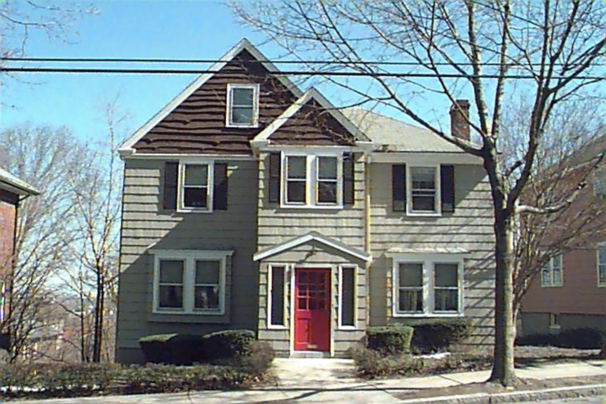
319 Mason Ter
Built:
1930Class:
Single Family HouseLand area:
5,625 sfFAR:
0.36Owner:
Lingyun JiaFY26:
$1,821,500 Δ2.77%| FY | Assessed | Change |
| 26 | $1,821,500 | 2.77% |
| 25 | $1,772,400 | 4.16% |
| 24 | $1,701,600 | 8.78% |
| 23 | $1,564,300 | 5.01% |
| 22 | $1,489,700 | 4.00% |
| 21 | $1,432,400 | 10.47% |
| 20 | $1,296,700 | 5.69% |
| 19 | $1,226,900 | 14.32% |
| 18 | $1,073,200 | 6.01% |
| 17 | $1,012,400 | 7.00% |
| 16 | $946,200 | 19.45% |
| 15 | $792,100 | 7.72% |
| 14 | $735,300 | 3.00% |
| 13 | $713,900 | 0.00% |
| 12 | $713,900 | 2.56% |
| 11 | $696,100 | 0.00% |
| 10 | $696,100 | 0.00% |
| 09 | $696,100 | 3.88% |
| 08 | $670,100 | -4.00% |
| 07 | $698,000 | 0.01% |
| 06 | $697,900 | 13.46% |
| 05 | $615,100 | 7.01% |
| 04 | $574,800 | 10.07% |
| 03 | $522,200 | 6.59% |
| 02 | $489,900 |
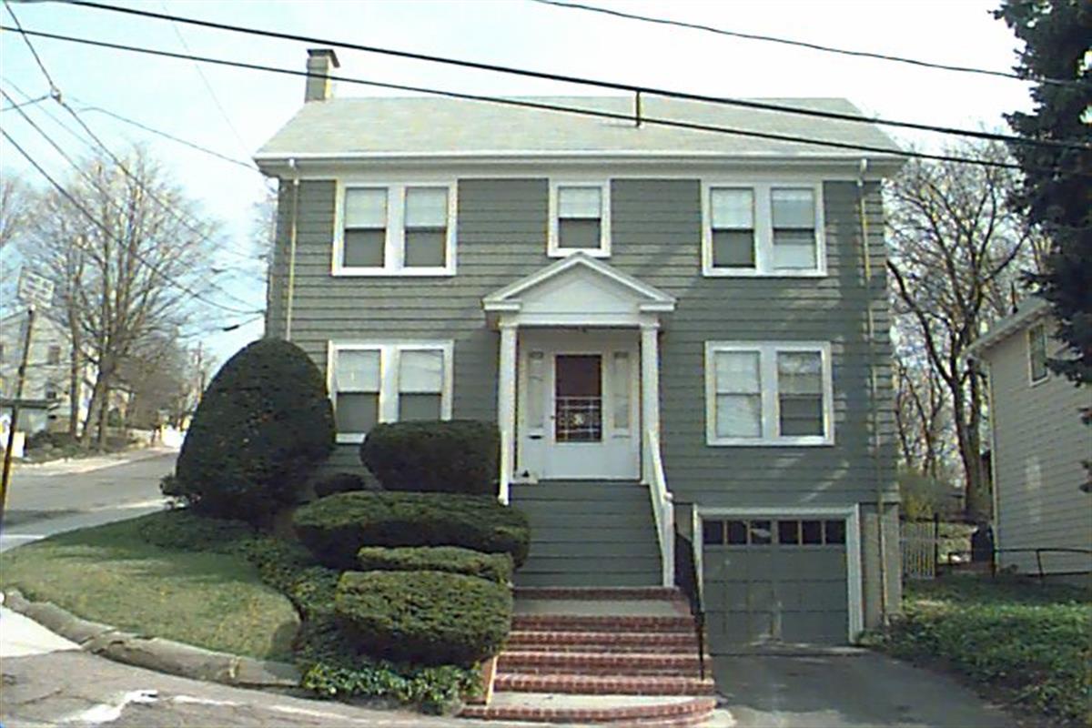
2 City View Rd
Built:
1939Class:
Single Family HouseLand area:
5,147 sfFAR:
0.30Owner:
Peninah S Rosengard TrFY26:
$1,869,000 Δ2.99%| FY | Assessed | Change |
| 26 | $1,869,000 | 2.99% |
| 25 | $1,814,700 | 4.04% |
| 24 | $1,744,200 | 10.76% |
| 23 | $1,574,800 | 5.00% |
| 22 | $1,499,800 | 4.00% |
| 21 | $1,442,100 | 10.19% |
| 20 | $1,308,700 | 5.00% |
| 19 | $1,246,400 | 14.03% |
| 18 | $1,093,000 | 5.44% |
| 17 | $1,036,600 | 7.00% |
| 16 | $968,800 | 18.84% |
| 15 | $815,200 | 5.86% |
| 14 | $770,100 | 3.02% |
| 13 | $747,500 | 0.66% |
| 12 | $742,600 | 20.85% |
| 11 | $614,500 | 1.12% |
| 10 | $607,700 | 0.00% |
| 09 | $607,700 | 9.26% |
| 08 | $556,200 | -4.00% |
| 07 | $579,400 | 0.02% |
| 06 | $579,300 | 9.24% |
| 05 | $530,300 | 7.02% |
| 04 | $495,500 | 28.67% |
| 03 | $385,100 | 0.65% |
| 02 | $382,600 |
18 Cypress St
Built:
1920Class:
Two-Family HouseLand area:
2,937 sfFAR:
0.79Owner:
Dmitriy Iokhvid; Lyuba EydlinFY26:
$1,648,900 Δ0.52%| FY | Assessed | Change |
| 26 | $1,648,900 | 0.52% |
| 25 | $1,640,300 | 1.71% |
| 24 | $1,612,800 | 10.93% |
| 23 | $1,453,900 | 5.01% |
| 22 | $1,384,600 | 4.00% |
| 21 | $1,331,400 | 3.81% |
| 20 | $1,282,500 | 5.00% |
| 19 | $1,221,400 | 6.60% |
| 18 | $1,145,800 | 8.00% |
| 17 | $1,060,900 | 9.99% |
| 16 | $964,500 | 10.00% |
| 15 | $876,800 | 10.28% |
| 14 | $795,100 | 5.01% |
| 13 | $757,200 | 0.00% |
| 12 | $757,200 | -0.71% |
| 11 | $762,600 | 0.00% |
| 10 | $762,600 | 0.00% |
| 09 | $762,600 | 6.46% |
| 08 | $716,300 | -2.42% |
| 07 | $734,100 | 0.00% |
| 06 | $734,100 | 18.67% |
| 05 | $618,600 | 7.01% |
| 04 | $578,100 | 10.01% |
| 03 | $525,500 | 14.19% |
| 02 | $460,200 |
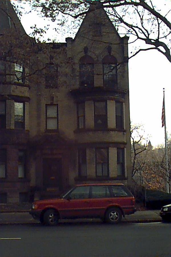
213 Gardner Rd
Built:
1888Class:
Single Family HouseLand area:
17,153 sfFAR:
0.24Owner:
Live Oak Number One IncFY26:
$3,408,200 Δ1.76%| FY | Assessed | Change |
| 26 | $3,408,200 | 1.76% |
| 25 | $3,349,400 | 2.95% |
| 24 | $3,253,500 | 12.40% |
| 23 | $2,894,500 | 5.00% |
| 22 | $2,756,700 | 4.00% |
| 21 | $2,650,600 | -7.56% |
| 20 | $2,867,500 | 5.00% |
| 19 | $2,730,900 | 9.74% |
| 18 | $2,488,600 | 6.00% |
| 17 | $2,347,700 | 8.33% |
| 16 | $2,167,100 | 7.00% |
| 15 | $2,025,300 | 5.36% |
| 14 | $1,922,200 | 3.00% |
| 13 | $1,866,200 | 0.00% |
| 12 | $1,866,200 | 0.91% |
| 11 | $1,849,300 | 1.08% |
| 10 | $1,829,500 | 1.60% |
| 09 | $1,800,700 | 14.84% |
| 08 | $1,568,000 | -3.95% |
| 07 | $1,632,400 | 0.00% |
| 06 | $1,632,400 | 6.73% |
| 05 | $1,529,500 | 12.75% |
| 04 | $1,356,600 | 11.04% |
| 03 | $1,221,700 | 25.14% |
| 02 | $976,300 |
Historic name:
Strong, William B. HouseNeighborhood:
Aspinwall HillStyle(s):
Queen Anne; Shingle StyleUse(s):
Single Family Dwelling HouseSignificance(s):
Architecture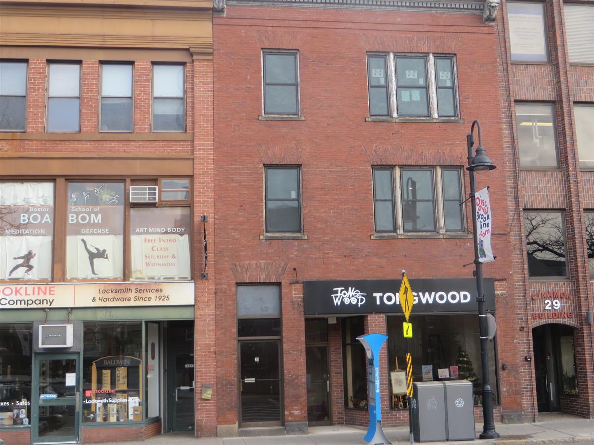
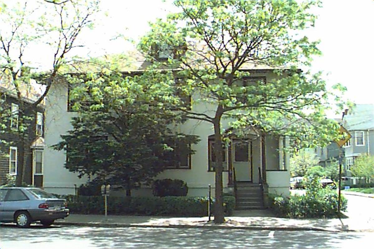
31-A Harvard St
Built:
1892Units:
2Class:
Residential with CommercialLand area:
2,846 sfFAR:
1.55Owner:
31 Harvard Street LLCFY26:
$1,972,800 Δ0.83%| FY | Assessed | Change |
| 26 | $1,972,800 | 0.83% |
| 25 | $1,956,500 | 5.23% |
| 24 | $1,859,200 | 1.96% |
| 23 | $1,823,500 | 4.48% |
| 22 | $1,745,300 | -0.30% |
| 21 | $1,750,600 | 2.09% |
| 20 | $1,714,800 | 5.29% |
| 19 | $1,628,700 | 2.02% |
| 18 | $1,596,500 | 14.02% |
| 17 | $1,400,200 | 8.07% |
| 16 | $1,295,700 | 6.99% |
| 15 | $1,211,000 | 8.87% |
| 14 | $1,112,300 | 4.92% |
| 13 | $1,060,100 | 0.19% |
| 12 | $1,058,100 | 0.75% |
| 11 | $1,050,200 | 0.86% |
| 10 | $1,041,200 | -11.18% |
| 09 | $1,172,300 | 16.91% |
| 08 | $1,002,700 | 6.85% |
| 07 | $938,400 | 1.04% |
| 06 | $928,700 | 16.09% |
| 05 | $800,000 | 9.44% |
| 04 | $731,000 | 11.43% |
| 03 | $656,000 | 18.84% |
| 02 | $552,000 |
Neighborhood:
Brookline VillageArchitect(s):
Untersee, Franz JosephStyle(s):
No styleUse(s):
Apartment House; Commercial BlockSignificance(s):
Architecture; Commerce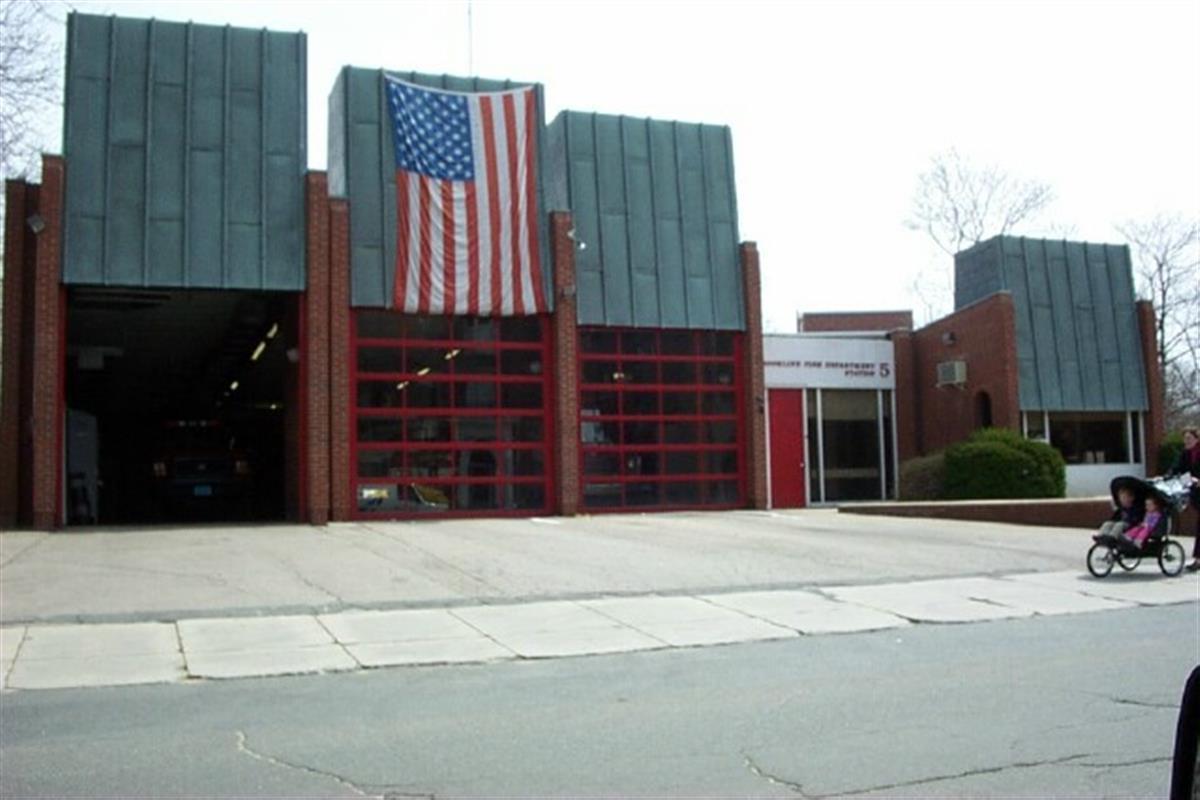
49 Babcock St
Built:
1965Class:
Municipal Public SafelyLand area:
25,935 sfFAR:
0.35Owner:
Town Of Brookline; C/O Fire Station #5FY26:
$4,852,700 Δ-2.97%| FY | Assessed | Change |
| 26 | $4,852,700 | -2.97% |
| 25 | $5,001,100 | -2.12% |
| 24 | $5,109,500 | 1.58% |
| 23 | $5,029,900 | 3.15% |
| 22 | $4,876,500 | -1.09% |
| 21 | $4,930,300 | -1.16% |
| 20 | $4,988,000 | 2.82% |
| 19 | $4,851,000 | 17.28% |
| 18 | $4,136,400 | 8.28% |
| 17 | $3,820,100 | -7.14% |
| 16 | $4,113,800 | 2.93% |
| 15 | $3,996,600 | -12.00% |
| 14 | $4,541,600 | 10.95% |
| 13 | $4,093,300 | 0.00% |
| 12 | $4,093,300 | 17.33% |
| 11 | $3,488,800 | 23.57% |
| 10 | $2,823,300 | 20.36% |
| 09 | $2,345,800 | -8.94% |
| 08 | $2,576,000 | 0.00% |
| 07 | $2,576,000 | 0.00% |
| 06 | $2,576,000 | 18.08% |
| 05 | $2,181,500 | 17.70% |
| 04 | $1,853,400 | 0.00% |
| 03 | $1,853,400 | 36.90% |
| 02 | $1,353,800 |
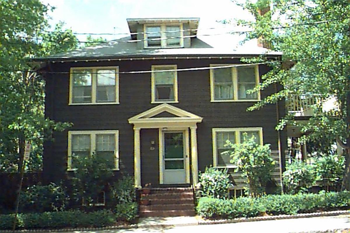
49 Davis Ave
Built:
1925Units:
2Class:
Residential CondominiumFY26:
$2,436,500 Δ3.50%Repeat search and uncheck condominium consolidation to view info by unit.
| FY | Assessed | Change |
| 26 | $2,436,500 | 3.50% |
| 25 | $2,354,100 | 2.00% |
| 24 | $2,308,000 | 8.49% |
| 23 | $2,127,400 | 3.00% |
| 22 | $2,065,500 | 1.00% |
| 21 | $2,045,100 | 4.39% |
| 20 | $1,959,100 | 15.15% |
| 19 | $1,701,400 | 5.00% |
| 18 | $1,620,400 | 8.01% |
| 17 | $1,500,300 | 9.99% |
| 16 | $1,364,000 | 10.01% |
| 15 | $1,239,900 | 7.74% |
| 14 | $1,150,800 | 4.99% |
| 13 | $1,096,100 | 0.00% |
| 12 | $1,096,100 | 3.51% |
| 11 | $1,058,900 | 0.00% |
| 10 | $1,058,900 | 0.00% |
| 09 | $1,058,900 | 4.29% |
| 08 | $1,015,300 | -2.92% |
| 07 | $1,045,800 | 3.00% |
| 06 | $1,015,300 |
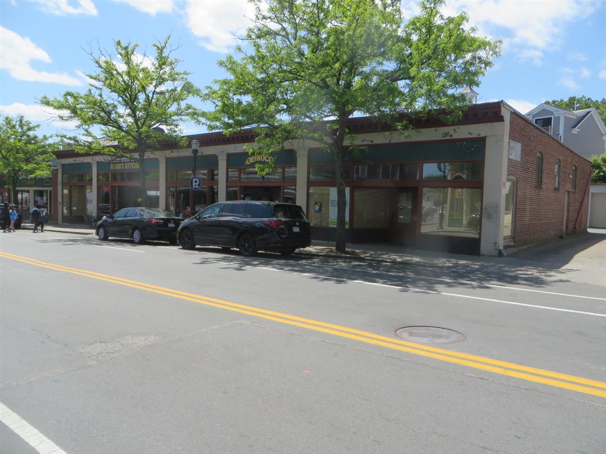
14 Harvard St
Built:
1910Class:
Small RetailLand area:
11,104 sfFAR:
0.48Owner:
Jerome M Tuck, TrFY26:
$4,607,700 Δ2.77%| FY | Assessed | Change |
| 26 | $4,607,700 | 2.77% |
| 25 | $4,483,300 | 1.87% |
| 24 | $4,400,900 | 9.40% |
| 23 | $4,022,700 | 3.16% |
| 22 | $3,899,600 | -4.53% |
| 21 | $4,084,600 | 0.00% |
| 20 | $4,084,600 | 5.36% |
| 19 | $3,876,800 | 23.26% |
| 18 | $3,145,300 | 5.83% |
| 17 | $2,971,900 | 8.33% |
| 16 | $2,743,300 | 7.69% |
| 15 | $2,547,400 | 28.81% |
| 14 | $1,977,600 | 5.17% |
| 13 | $1,880,400 | 3.64% |
| 12 | $1,814,400 | -2.07% |
| 11 | $1,852,800 | -1.65% |
| 10 | $1,883,800 | 9.66% |
| 09 | $1,717,900 | 6.36% |
| 08 | $1,615,100 | 5.88% |
| 07 | $1,525,400 | 1.19% |
| 06 | $1,507,400 | -2.81% |
| 05 | $1,551,000 | 10.86% |
| 04 | $1,399,000 | 7.04% |
| 03 | $1,307,000 | 17.01% |
| 02 | $1,117,000 |
Neighborhood:
Brookline VillageStyle(s):
Classical RevivalUse(s):
Commercial BlockSignificance(s):
Architecture; CommerceDemolition allowed:
2025-12-09partial demolition, National Register district
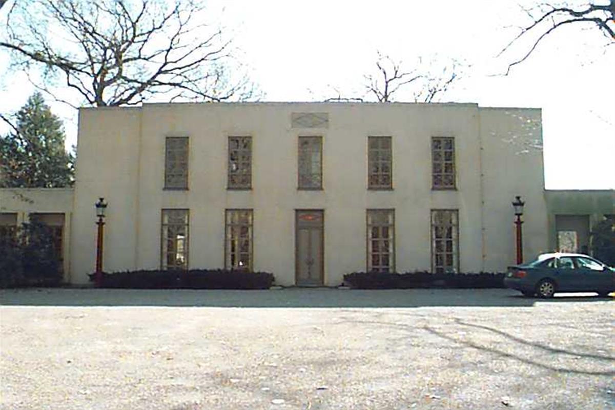
1495 Beacon St
Built:
1900Units:
4Class:
Residential CondominiumFY26:
$2,842,900 Δ5.33%Repeat search and uncheck condominium consolidation to view info by unit.
| FY | Assessed | Change |
| 26 | $2,842,900 | 5.33% |
| 25 | $2,699,000 | -0.12% |
| 24 | $2,702,200 | 1.32% |
| 23 | $2,667,100 | 7.66% |
| 22 | $2,477,300 | 1.00% |
| 21 | $2,452,800 | 0.99% |
| 20 | $2,428,700 | 5.00% |
| 19 | $2,313,000 | 6.83% |
| 18 | $2,165,200 | 8.01% |
| 17 | $2,004,700 | 10.00% |
| 16 | $1,822,500 | 10.01% |
| 15 | $1,656,700 | 10.66% |
| 14 | $1,497,100 | 4.99% |
| 13 | $1,425,900 | -0.37% |
| 12 | $1,431,200 | -1.71% |
| 11 | $1,456,100 | 0.80% |
| 10 | $1,444,600 | 0.00% |
| 09 | $1,444,600 | 3.16% |
| 08 | $1,400,300 | -1.99% |
| 07 | $1,428,800 | 2.99% |
| 06 | $1,387,300 | 10.08% |
| 05 | $1,260,300 | 7.00% |
| 04 | $1,177,800 | 6.99% |
| 03 | $1,100,800 | 24.33% |
| 02 | $885,400 |
Demolition allowed:
2025-12-09storage buildings/greenhouse, National Register property
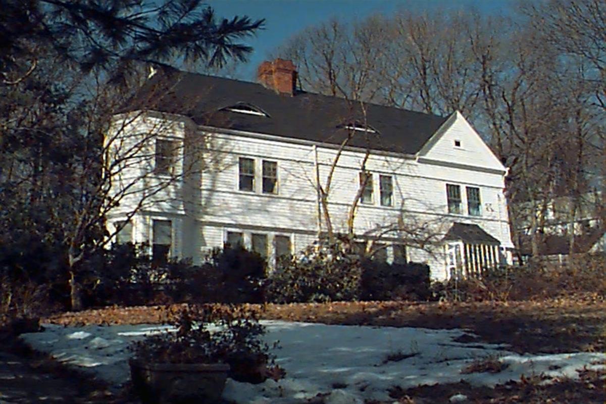
282 Newton St
Built:
c1778Units:
5Class:
Residential with AgriculturalLand area:
2,121,437 sfFAR:
0.02Owner:
Edward P Lawrence, et al TrsFY26:
$23,591,900 Δ2.09%| FY | Assessed | Change |
| 26 | $23,591,900 | 2.09% |
| 25 | $23,109,900 | 1.75% |
| 24 | $22,711,900 | 14.93% |
| 23 | $19,761,000 | 7.57% |
| 22 | $18,370,800 | 2.33% |
| 21 | $17,951,700 | 5.89% |
| 20 | $16,952,600 | 4.55% |
| 19 | $16,215,100 | 5.89% |
| 18 | $15,313,000 | 5.43% |
| 17 | $14,524,300 | 7.89% |
| 16 | $13,461,600 | 8.68% |
| 15 | $12,386,900 | 11.45% |
| 14 | $11,114,700 | 2.96% |
| 13 | $10,795,300 | 0.00% |
| 12 | $10,795,300 | 5.10% |
| 11 | $10,271,000 | 0.10% |
| 10 | $10,260,800 | 0.21% |
| 09 | $10,239,300 | -13.95% |
| 08 | $11,899,700 | -4.03% |
| 07 | $12,399,900 | 0.00% |
| 06 | $12,399,900 | 8.89% |
| 05 | $11,387,500 |
Historic name:
Harris, John House and FarmCommon name:
Allandale FarmNeighborhood:
Mount WalleyStyle(s):
FederalUse(s):
Agricultural; Single Family Dwelling HouseSignificance(s):
Agriculture; ArchitectureDesignation(s):
Nat'l Register Individual Property (10/17/1985); Nat'l Register MRA (10/17/1985)